Trail Walking L'Hospitalet - 56-L'Hospitallet-contras-Le Goi- Col St Vincent- L'Hospitallet - Photo

56-L'Hospitallet-contras-Le Goi- Col St Vincent- L'Hospitallet

 dumotier
dumotier

User

© OpenStreetMap contributors
Length
Length
18.3 km
Max alt
Max alt
1628 m
Uphill gradient
Uphill gradient
867 m
Km-Effort
Km-Effort  
30 km
Min alt
Min alt
885 m
Downhill gradient
Downhill gradient
867 m
Boucle
Boucle
Yes
Creation date :
2014-12-10 00:00:00.0
Updated on :
2014-12-10 00:00:00.0

(0 Reviews)

Walking
Walking
4h12
Difficulty : Medium

Scan this QR Code to open this trail in the SityTrail application

FREE GPS app for hiking

Logo SityTrail SityTrail

IGN / Geographical institutes

Download SityTrail from the App Store Download SityTrail from Google Play

Logo SityTrail SityTrail World

The world is yours!

Download SityTrail from the App Store Download SityTrail from Google Play Download SityTrail on Huawei AppGallery

About

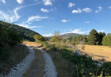
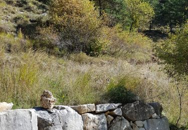
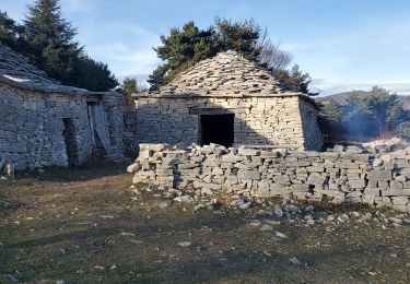
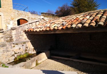
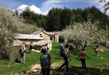
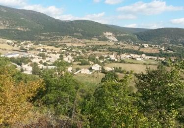
Trail Walking of 18.3 km to be discovered at Provence-Alpes-Côte d'Azur, Alpes-de-Haute-Provence, L'Hospitalet. This trail is proposed by dumotier.

Elevation profile

Photos

Points of interest

Point of interest Lardiers - Vers le Sud - Photo
dumotier
LARDIERS 
Point of interest Lardiers - 1624m La tour de vigie - Photo
dumotier
Point of interest Lardiers - 1633m vers le Contras - Photo
dumotier
Point of interest Lardiers - 1619m à coté du Contras - Photo
dumotier
Point of interest L'Hospitalet - Point 20 - Photo
dumotier
L'HOSPITALET 
Point of interest L'Hospitalet - De la pointe 1629m vers l'Oisans - Photo
dumotier
Point of interest L'Hospitalet - Du GOI vers le Dauphiné - Photo
dumotier
Point of interest L'Hospitalet - Point 27 - Photo
dumotier
L'HOSPITALET 
Point of interest L'Hospitalet - Du GOI vers le Dauphiné - Photo
dumotier
Point of interest Châteauneuf-Miravail - Col St Vincent - Photo
dumotier
CHÂTEAUNEUF-MIRAVAIL 

Positioning

Country:
France
Region :
Provence-Alpes-Côte d'Azur
Department/Province :
Alpes-de-Haute-Provence
Municipality :
L'Hospitalet
Location:
Unknown
Start:(UTM)
716095 ; 4885198 (31T) N.

Trails nearby

Trail Walking Saumane - SAUMANE JAS DE LA CHAPELAINE O N ** - Photo
Walking
RobinMicheline

Walking

Difficult
Saumane, Provence-Alpes-Côte d'Azur, Alpes-de-Haute-Provence, France
17 km | 26 km-effort
4h 48min
Yes
Trail Walking La Rochegiron - Vières - Font Martine - La Blanchère - Photo
Walking
dsurin

Walking

Easy
La Rochegiron, Provence-Alpes-Côte d'Azur, Alpes-de-Haute-Provence, France
9 km | 12 km-effort
2h 26min
Yes
Trail Walking Saumane - Bergeries du Contras depuis Saumane - Photo
Walking
Daniel.BRUN-PICARD

Walking

Medium
(1)
Saumane, Provence-Alpes-Côte d'Azur, Alpes-de-Haute-Provence, France
12.1 km | 18.3 km-effort
3h 23min
Yes
Trail Walking La Rochegiron - 04 - VIERE, la Font Martine  - Photo
Walking
chris13370

Walking

Easy
La Rochegiron, Provence-Alpes-Côte d'Azur, Alpes-de-Haute-Provence, France
7.9 km | 11.6 km-effort
2h 30min
Yes
Trail Walking Saumane - saumane Treboux 20kms 920m - Photo
Walking
Danielba

Walking

Very difficult
Saumane, Provence-Alpes-Côte d'Azur, Alpes-de-Haute-Provence, France
20 km | 32 km-effort
7h 39min
Yes
Trail Walking La Rochegiron - La Blanchère au départ du Jonquet - Photo
Walking
PITOUSSAINT

Walking

Easy
La Rochegiron, Provence-Alpes-Côte d'Azur, Alpes-de-Haute-Provence, France
10.7 km | 14.9 km-effort
4h 34min
Yes
Trail Walking Saumane - Les Bergeries du Contras - Photo
Walking
lviallet

Walking

Medium
Saumane, Provence-Alpes-Côte d'Azur, Alpes-de-Haute-Provence, France
14.7 km | 22 km-effort
4h 36min
Yes
Trail Walking Saumane - les vraies richesses - Photo
Walking
blacas

Walking

Medium
Saumane, Provence-Alpes-Côte d'Azur, Alpes-de-Haute-Provence, France
23 km | 36 km-effort
7h 31min
Yes
Trail Walking Saumane - Saumane - Les Bergeries du Contras - Banon  - Photo
Walking
tracegps

Walking

Difficult
Saumane, Provence-Alpes-Côte d'Azur, Alpes-de-Haute-Provence, France
16.1 km | 24 km-effort
5h 15min
Yes


Close
My subscriptions