Trail Other activity Fleurigné - gr34anc - Photo
© OpenStreetMap contributors
Length
Length
16.2 km
Max alt
Max alt
162 m
Uphill gradient
Uphill gradient
248 m
Km-Effort
Km-Effort  
19.3 km
Min alt
Min alt
79 m
Downhill gradient
Downhill gradient
185 m
Boucle
Boucle
No
Creation date :
2014-12-10 00:00:00.0
Updated on :
2014-12-10 00:00:00.0

(0 Reviews)

Other activity
Other activity
--
Difficulty : Unknown

Scan this QR Code to open this trail in the SityTrail application

FREE GPS app for hiking

Logo SityTrail SityTrail

IGN / Geographical institutes

Download SityTrail from the App Store Download SityTrail from Google Play

Logo SityTrail SityTrail World

The world is yours!

Download SityTrail from the App Store Download SityTrail from Google Play Download SityTrail on Huawei AppGallery

About

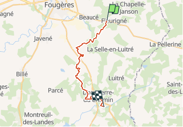
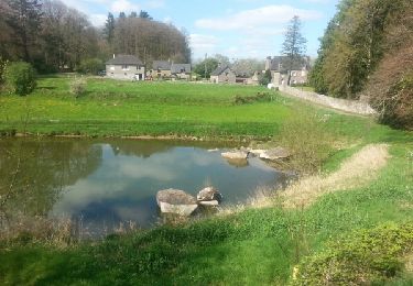
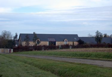
Trail Other activity of 16.2 km to be discovered at Brittany, Ille-et-Vilaine, Fleurigné. This trail is proposed by leclerc-ray.

Description

ffleurigné-saut roland

Elevation profile

Positioning

Country:
France
Region :
Brittany
Department/Province :
Ille-et-Vilaine
Municipality :
Fleurigné
Location:
Unknown
Start:(UTM)
638530 ; 5355356 (30U) N.

Trails nearby

Trail On foot La Chapelle-Janson - Circuit du Relais des Vallées - Photo
On foot
GUIDE+

On foot

Easy
La Chapelle-Janson, Brittany, Ille-et-Vilaine, France
12.8 km | 15.9 km-effort
3h 36min
Yes
Trail Walking La Chapelle-Janson - GR_37_AG_21_Chapelle-Janson_Luitre-Dompierre_20210620 - Photo
Walking
patrickdanilo

Walking

Difficult
La Chapelle-Janson, Brittany, Ille-et-Vilaine, France
13.1 km | 16.2 km-effort
3h 16min
No
Trail Walking Fougères - GR_37_AF_20_Fougeres_Chapelle-Janson_20210619 - Photo
Walking
patrickdanilo

Walking

Easy
Fougères, Brittany, Ille-et-Vilaine, France
9.9 km | 12.5 km-effort
2h 28min
No
Trail Nordic walking Fougères - grolay nichecoucou GR34 19km - Photo
Nordic walking
coglais

Nordic walking

Medium
(1)
Fougères, Brittany, Ille-et-Vilaine, France
19.2 km | 24 km-effort
3h 20min
Yes
Trail Nordic walking Fougères - niche coucou Cotterèts 11 Bis - Photo
Nordic walking
GUIDE
yago1404

Nordic walking

Very easy
Fougères, Brittany, Ille-et-Vilaine, France
11.1 km | 14.1 km-effort
2h 31min
Yes
Trail Walking La Chapelle-Janson - GR 34 étape 3 - Photo
Walking
lagardienne

Walking

Easy
La Chapelle-Janson, Brittany, Ille-et-Vilaine, France
28 km | 34 km-effort
6h 55min
No
Trail Running Fougères - Fougères boucle 5 - Photo
Running
tracegps

Running

Medium
Fougères, Brittany, Ille-et-Vilaine, France
8.8 km | 9.8 km-effort
1h 0min
Yes
Trail Mountain bike Fougères - Fougères boucle 5 - Photo
Mountain bike
tracegps

Mountain bike

Easy
Fougères, Brittany, Ille-et-Vilaine, France
8.8 km | 9.8 km-effort
45min
Yes
Trail Walking Fougères - Fougères boucle 5 - Photo
Walking
tracegps

Walking

Medium
Fougères, Brittany, Ille-et-Vilaine, France
8.8 km | 9.8 km-effort
2h 30min
Yes


Close
My subscriptions