Trail Walking Saint-Aignan - Lac de Guerlédan rive sud - Saint Aignan - Photo

Lac de Guerlédan rive sud - Saint Aignan

 tracegps
tracegps

User

© OpenStreetMap contributors
Length
Length
15.5 km
Max alt
Max alt
234 m
Uphill gradient
Uphill gradient
423 m
Km-Effort
Km-Effort  
21 km
Min alt
Min alt
75 m
Downhill gradient
Downhill gradient
423 m
Boucle
Boucle
Yes
Creation date :
2014-12-10 00:00:00.0
Updated on :
2014-12-10 00:00:00.0

(2 Reviews)

Walking
Walking
4h30
Difficulty : Medium

Scan this QR Code to open this trail in the SityTrail application

FREE GPS app for hiking

Logo SityTrail SityTrail

IGN / Geographical institutes

Download SityTrail from the App Store Download SityTrail from Google Play

Logo SityTrail SityTrail World

The world is yours!

Download SityTrail from the App Store Download SityTrail from Google Play Download SityTrail on Huawei AppGallery

About

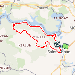
Trail Walking of 15.5 km to be discovered at Brittany, Morbihan, Saint-Aignan. This trail is proposed by tracegps.

Description

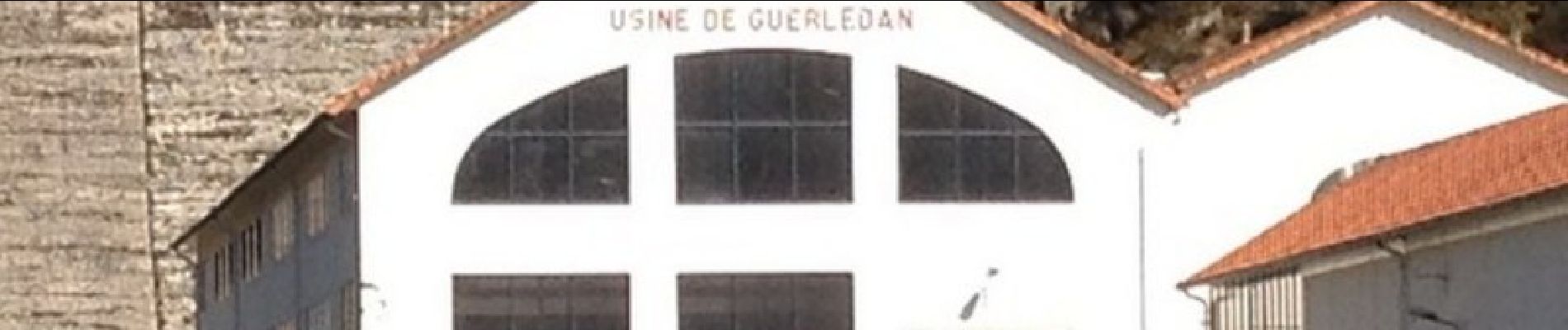
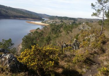
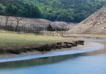
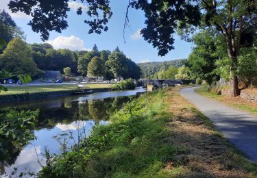
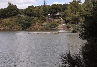
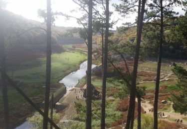
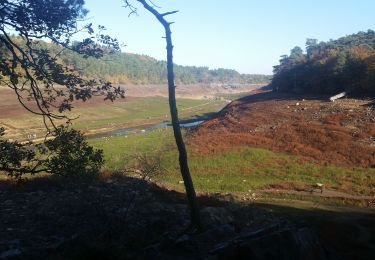
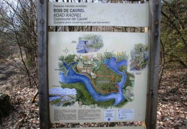
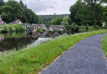
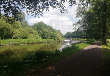
Lac de Guerlédan Rive Sud - de Saint-Aignan à l’anse de Sordan - retour par le GR341S sentier de rive et le barrage. Départ parking de l’église paroissiale (15ème siècle) de Saint-Aignan aux retables en bois sculpté et peint, direction le bois de Toul er Roch avec ses sentiers pédagogiques et l’ancienne carrière Botlan que nous quittons pour rejoindre la maison de la nature. Ensuite descente vers l’anse de Sordan avec son mouillage. On aperçoit en face l’embarcadère de beau Rivage avec ses vedettes pour découvrir Le lac retour par le GR 341S sentier caillouteux de rive avec un détour à la chapelle Sainte-Tréphine (19ème siècle) pour un beau point de vue. Descente ensuite vers le haut du barrage où l’on aperçoit les conduites forcées et l’usine hydroélectrique mise en service en 1929 (puissance de 15 MW équivalent à la consommation de 15000 habitants). Retour ensuite vers Saint-Aignan ou nous pouvons voir les équipements électrotechniques du musée de l’électricité.

Elevation profile

Photos

Positioning

Country:
France
Region :
Brittany
Department/Province :
Morbihan
Municipality :
Saint-Aignan
Location:
Unknown
Start:(UTM)
499025 ; 5336453 (30U) N.

Comments

Please log in to post a review or rate the element


Très agréable rando. A noter que la fin le long du lac est un peu lassante sans doute à cause des mutiples bateaux à moteur qui le sillonnent bruyamment...


Trails nearby

Trail Walking Caurel - PR_22_Caurel_AA_01_Circuit1b_Des-Landes-De-Caurel_20150308 - Photo
Walking
patrickdanilo

Walking

Medium
Caurel, Brittany, Côtes-d'Armor, France
14.3 km | 18.4 km-effort
4h 28min
Yes
Trail On foot Caurel - Bois de Caurel - Photo
On foot
PRO

On foot

Easy
Caurel, Brittany, Côtes-d'Armor, France
5.3 km | 6.8 km-effort
1h 32min
Yes
Trail Walking Guerlédan - GR_37_DG_27_Guerledan_Bon-Repos-Blavet_20210828 - Photo
Walking
patrickdanilo

Walking

Easy
Guerlédan, Brittany, Côtes-d'Armor, France
19.5 km | 24 km-effort
6h 33min
No
Trail Walking Guerlédan - Variante Guerledan bois de Cornnec Landronnec Voie verte - Photo
Walking
michelberrier

Walking

Very easy
Guerlédan, Brittany, Côtes-d'Armor, France
8.2 km | 10.8 km-effort
3h 8min
Yes
Trail Walking Bon Repos sur Blavet - PR_22_Bon-Repos_AA_01_Circuit4_Tregnanton-Et-Lac-Assec_20151025 - Photo
Walking
patrickdanilo

Walking

Easy
Bon Repos sur Blavet, Brittany, Côtes-d'Armor, France
10 km | 11.8 km-effort
2h 34min
Yes
Trail Walking Saint-Aignan - GUERLEDAN_02_SORDAN_LAC-A-SEC - Photo
Walking
patrickdanilo

Walking

Easy
Saint-Aignan, Brittany, Morbihan, France
24 km | 29 km-effort
5h 22min
No
Trail Walking Guerlédan - Lac de Guerlédan rive Nord - Landroanec - Photo
Walking
tracegps

Walking

Difficult
Guerlédan, Brittany, Côtes-d'Armor, France
16.8 km | 21 km-effort
5h 0min
Yes
Trail Walking Saint-Aignan - guerledan - Photo
Walking
jimmy46

Walking

Medium
Saint-Aignan, Brittany, Morbihan, France
18.9 km | 23 km-effort
3h 39min
Yes
Trail Hybrid bike Guerlédan - Mur de Bretagne Josselin - Photo
Hybrid bike
Roulland

Hybrid bike

Easy
Guerlédan, Brittany, Côtes-d'Armor, France
74 km | 81 km-effort
4h 9min
No


Close
My subscriptions