![](/images/other/stat-length.png)
![Trail Walking Pleucadeuc - Circuit de Saint Marc - Pleucadeuc - Photo](https://media.geolcdn.com/t/1900/400/ext.pjpeg?maxdim=2&url=https%3A%2F%2Fstatic1.geolcdn.com%2Fsiteimages%2Fupload%2Ffiles%2F1553511878bg_sport_marche.png)
Circuit de Saint Marc - Pleucadeuc
tracegps
User
![Length](/images/other/stat-length.png)
![Max alt](https://static1.geolcdn.com/siteimages/upload/files/1508320355ic_sort_altitude_max_24dp.png)
![Uphill gradient](https://static1.geolcdn.com/siteimages/upload/files/1508320355ic_sort_den_pos_24dp.png)
![Km-Effort](/images/other/stat-length.png)
![Min alt](https://static1.geolcdn.com/siteimages/upload/files/1508320355ic_sort_altitude_min_24dp.png)
![Downhill gradient](https://static1.geolcdn.com/siteimages/upload/files/1508320355ic_sort_den_neg_24dp.png)
![Boucle](https://static1.geolcdn.com/siteimages/upload/files/16400158638029165_repeat_loop_refresh_sync_direction_icon.png)
![Walking](https://static1.geolcdn.com/sitytour/trail-icons/101.png)
5h30
Difficulty : Medium
![Scan this QR Code to open this trail in the SityTrail application](https://capi.geolives.com/qq0zvz2zws4bq2lad0pu/sitytour/trails/112529/qr.png?size=200)
FREE GPS app for hiking
About
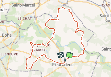
Trail Walking of 22 km to be discovered at Brittany, Morbihan, Pleucadeuc. This trail is proposed by tracegps.
Description
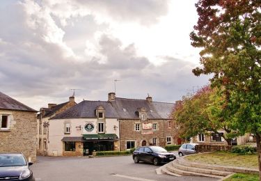
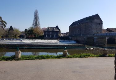
Point de départ : mairie de Pleucadeuc - Coordonnées GPS : 02°22’24’’O / 47°45’34’’N - Distance : 22 km - 5 h 30 A voir en chemin: 1. Pleucadeuc, le village des jumeaux : commune de 1747 habitants située à 70 mètres d’altitude, Pleucadeuc est essentiellement connue pour son rassemblement annuel « des deux et plus » qui réunit chaque 15 août entre 1000 et 2000 jumeaux, triplés, quadruplés de France et d'ailleurs. 2. La vallée de la Claie : la Claie est une rivière de première catégorie, longue de 63 kms qui traverse 13 communes du Morbihan. Elle prend sa source aux alentours de Moréac et s'oriente d'abord en direction du sud entre Bignan et Saint-Jean-Brévelay. Elle s'incline ensuite vers l'est en suivant les Landes de Lanvaux avant de confluer avec l'Oust à Saint-Congard. 3. La chapelle Saint Marc : elle est édifiée sur une crête dominant un très beau panorama sur la vallée de l’Oust. La première construction datait du XVème siècle. En 1896, elle menaçait de ruine. En 1902, une chapelle neuve fut édifiée, avec seul souvenir du passé, une pierre tumulaire scellée à l’intérieur coté évangile. 4. La chapelle Saint Barthélémy (fin XIVème – début XVème siècle) : la chapelle est en forme de croix latine, les fenêtres ogivales en tiers points. La charpente est apparente. Entourant la chapelle, un cimentière, où l’on remarque un petit menhir arrondi, est encore utilisé pour des sépultures. De vieux ifs, dont l’un, âgé de 400 ans environ, mesure 4,30 m de circonférence à sa base, semblent être le souvenir d’une ancienne coutume celte. Points 3 et 4 : informations tirées de l’ouvrage de Denise Josse-élicot «Pleucadeuc» Contact: Communauté de Communes du Val d’Oust et de Lanvaux - Tél : 02 97 75 01 02 – Email : ccvol (at) ccvol.com
Positioning
Comments
Trails nearby
![Trail On foot Molac - Circuit du Lindeul - Photo](https://media.geolcdn.com/t/375/260/ext.jpg?maxdim=2&url=https%3A%2F%2Fmedia.geolcdn.com%2Ff%2F3aa1e84e-ce74-4370-bd25-7aa11869dba2.jpeg)
![On foot On foot](https://static1.geolcdn.com/sitytour/trail-icons/100.png)
On foot
![](/images/other/stat-length.png)
![](https://static1.geolcdn.com/siteimages/upload/files/16400158638029165_repeat_loop_refresh_sync_direction_icon.png)
![Trail Walking Saint-Laurent-sur-Oust - Gr-347_03_St-Laurent-Sur-Oust_La-Ville-André _20190332 - Photo](https://media.geolcdn.com/t/375/260/ext.jpg?maxdim=2&url=https%3A%2F%2Fmedia.geolcdn.com%2Ff%2F16c87b33-7868-4a56-a383-13a739f11a40.jpg)
![Walking Walking](https://static1.geolcdn.com/sitytour/trail-icons/101.png)
Walking
![](/images/other/stat-length.png)
![](https://static1.geolcdn.com/siteimages/upload/files/16400158638029165_repeat_loop_refresh_sync_direction_icon.png)
![Trail Walking Saint-Congard - 179 rando sur les pentes du mont Hersé - Photo](https://media.geolcdn.com/t/375/260/ext.jpg?maxdim=2&url=https%3A%2F%2Fmedia.geolcdn.com%2Ff%2Fc77b0db8-e005-400b-8755-a7e31b3bb985.jpg)
![Walking Walking](https://static1.geolcdn.com/sitytour/trail-icons/101.png)
Walking
![](/images/other/stat-length.png)
![](https://static1.geolcdn.com/siteimages/upload/files/16400158638029165_repeat_loop_refresh_sync_direction_icon.png)
![Trail Hybrid bike Pluherlin - 2020-07-21_23h42m24_activity_5270837265 - Photo](https://media.geolcdn.com/t/375/260/ext.jpg?maxdim=2&url=https%3A%2F%2Fmedia.geolcdn.com%2Ff%2F7412425f-3f43-4df7-bd4e-10a0fd71cd85.jpg)
![Hybrid bike Hybrid bike](https://static1.geolcdn.com/sitytour/trail-icons/203.png)
Hybrid bike
![](/images/other/stat-length.png)
![](https://static1.geolcdn.com/siteimages/upload/files/16400158638029165_repeat_loop_refresh_sync_direction_icon.png)
![Trail Walking Pleucadeuc - 174 rando du bas Bohal - Photo](https://media.geolcdn.com/t/375/260/ext.jpg?maxdim=2&url=https%3A%2F%2Fmedia.geolcdn.com%2Ff%2F72e5836f-5a04-4a8e-a1cf-e46185093254.jpg)
![Walking Walking](https://static1.geolcdn.com/sitytour/trail-icons/101.png)
Walking
![](/images/other/stat-length.png)
![](https://static1.geolcdn.com/siteimages/upload/files/16400158638029165_repeat_loop_refresh_sync_direction_icon.png)
![Trail Hybrid bike Pluherlin - autour de phuherlin - Photo](https://media.geolcdn.com/t/375/260/ext.jpg?maxdim=2&url=https%3A%2F%2Fstatic1.geolcdn.com%2Fsiteimages%2Fupload%2Ffiles%2F1524743154velo.jpg)
![Hybrid bike Hybrid bike](https://static1.geolcdn.com/sitytour/trail-icons/203.png)
Hybrid bike
![](/images/other/stat-length.png)
![](https://static1.geolcdn.com/siteimages/upload/files/16400158638029165_repeat_loop_refresh_sync_direction_icon.png)
![Trail Walking Pleucadeuc - Circuit de Saint Marc - Pleucadeuc - Photo](https://media.geolcdn.com/t/375/260/ext.jpg?maxdim=2&url=https%3A%2F%2Fstatic1.geolcdn.com%2Fsiteimages%2Fupload%2Ffiles%2F1553511878bg_sport_marche.png)
![Walking Walking](https://static1.geolcdn.com/sitytour/trail-icons/101.png)
Walking
![](/images/other/stat-length.png)
![](https://static1.geolcdn.com/siteimages/upload/files/16400158638029165_repeat_loop_refresh_sync_direction_icon.png)
![Trail Cycle Molac - autour de Molac - Photo](https://media.geolcdn.com/t/375/260/ext.jpg?maxdim=2&url=https%3A%2F%2Fstatic1.geolcdn.com%2Fsiteimages%2Fupload%2Ffiles%2F1524743154velo.jpg)
![Cycle Cycle](https://static1.geolcdn.com/sitytour/trail-icons/200.png)
![Trail Walking Pleucadeuc - pleucadeuc - Photo](https://media.geolcdn.com/t/375/260/ext.jpg?maxdim=2&url=https%3A%2F%2Fstatic1.geolcdn.com%2Fsiteimages%2Fupload%2Ffiles%2F1553511878bg_sport_marche.png)
![Walking Walking](https://static1.geolcdn.com/sitytour/trail-icons/101.png)
Walking
![](/images/other/stat-length.png)
![](https://static1.geolcdn.com/siteimages/upload/files/16400158638029165_repeat_loop_refresh_sync_direction_icon.png)