![](/images/other/stat-length.png)
![Trail Walking Cernusson - Les Layons de Cernusson - Photo](https://media.geolcdn.com/t/1900/400/ext.pjpeg?maxdim=2&url=https%3A%2F%2Fservices.sitytrail.com%2FGeolivesWS%2FDownloadMedia.ashx%3FTrailID%3D111531%26Media%3D7556_3.jpg)
Les Layons de Cernusson
tracegps
User
![Length](/images/other/stat-length.png)
Length
10.5 km
![Max alt](https://static1.geolcdn.com/siteimages/upload/files/1508320355ic_sort_altitude_max_24dp.png)
Max alt
125 m
![Uphill gradient](https://static1.geolcdn.com/siteimages/upload/files/1508320355ic_sort_den_pos_24dp.png)
Uphill gradient
110 m
![Km-Effort](/images/other/stat-length.png)
Km-Effort
11.9 km
![Min alt](https://static1.geolcdn.com/siteimages/upload/files/1508320355ic_sort_altitude_min_24dp.png)
Min alt
82 m
![Downhill gradient](https://static1.geolcdn.com/siteimages/upload/files/1508320355ic_sort_den_neg_24dp.png)
Downhill gradient
111 m
![Boucle](https://static1.geolcdn.com/siteimages/upload/files/16400158638029165_repeat_loop_refresh_sync_direction_icon.png)
Boucle
Yes
Creation date :
2014-12-10 00:00:00.0
Updated on :
2014-12-10 00:00:00.0
![Walking](https://static1.geolcdn.com/sitytour/trail-icons/101.png)
2h40
Difficulty : Medium
![Scan this QR Code to open this trail in the SityTrail application](https://capi.geolives.com/qq0zvz2zws4bq2lad0pu/sitytour/trails/111531/qr.png?size=200)
FREE GPS app for hiking
About
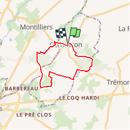
Trail Walking of 10.5 km to be discovered at Pays de la Loire, Maine-et-Loire, Cernusson. This trail is proposed by tracegps.
Description
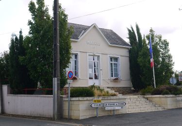
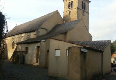
Circuit proposé par l’Office de tourisme du Vihiersois-Haut Layon. Départ de l’église de Cernusson. Retrouvez le circuit sur le site de l’Office de tourisme du Vihiersois-Haut Layon.
Positioning
Country:
France
Region :
Pays de la Loire
Department/Province :
Maine-et-Loire
Municipality :
Cernusson
Location:
Unknown
Start:(Dec)
Start:(UTM)
690785 ; 5227709 (30T) N.
Comments
Trails nearby
![Trail On foot Lys-Haut-Layon - Le sentier de la Chapelle Richard - Photo](https://media.geolcdn.com/t/375/260/ext.jpg?maxdim=2&url=https%3A%2F%2Fmedia.geolcdn.com%2Ff%2F568d9ad5-3d3d-44cb-a490-e5a9819195c2.jpeg)
![On foot On foot](https://static1.geolcdn.com/sitytour/trail-icons/100.png)
Le sentier de la Chapelle Richard
On foot
Easy
Lys-Haut-Layon,
Pays de la Loire,
Maine-et-Loire,
France
![](/images/other/stat-length.png)
3.9 km | 4.4 km-effort
59min
![](https://static1.geolcdn.com/siteimages/upload/files/16400158638029165_repeat_loop_refresh_sync_direction_icon.png)
No
![Trail On foot Lys-Haut-Layon - Le sentier du chêne aux loups - Photo](https://media.geolcdn.com/t/375/260/ext.jpg?maxdim=2&url=https%3A%2F%2Fmedia.geolcdn.com%2Ff%2F568d9ad5-3d3d-44cb-a490-e5a9819195c2.jpeg)
![On foot On foot](https://static1.geolcdn.com/sitytour/trail-icons/100.png)
Le sentier du chêne aux loups
On foot
Easy
Lys-Haut-Layon,
Pays de la Loire,
Maine-et-Loire,
France
![](/images/other/stat-length.png)
4 km | 4.8 km-effort
1h 4min
![](https://static1.geolcdn.com/siteimages/upload/files/16400158638029165_repeat_loop_refresh_sync_direction_icon.png)
No
![Trail On foot Lys-Haut-Layon - Les Layons de Cernusson - Photo](https://media.geolcdn.com/t/375/260/ext.jpg?maxdim=2&url=https%3A%2F%2Fmedia.geolcdn.com%2Ff%2F5f869b7d-198e-45f6-919a-a66d7ecadb04.jpeg)
![On foot On foot](https://static1.geolcdn.com/sitytour/trail-icons/100.png)
Les Layons de Cernusson
On foot
Easy
Lys-Haut-Layon,
Pays de la Loire,
Maine-et-Loire,
France
![](/images/other/stat-length.png)
4.2 km | 4.9 km-effort
1h 7min
![](https://static1.geolcdn.com/siteimages/upload/files/16400158638029165_repeat_loop_refresh_sync_direction_icon.png)
No
![Trail On foot Lys-Haut-Layon - Le sentier des Trois Monts - Photo](https://media.geolcdn.com/t/375/260/ext.jpg?maxdim=2&url=https%3A%2F%2Fstatic1.geolcdn.com%2Fsiteimages%2Fupload%2Ffiles%2F1545311037marcheuse_200dpi.jpg)
![On foot On foot](https://static1.geolcdn.com/sitytour/trail-icons/100.png)
Le sentier des Trois Monts
On foot
Easy
Lys-Haut-Layon,
Pays de la Loire,
Maine-et-Loire,
France
![](/images/other/stat-length.png)
11.9 km | 13.8 km-effort
3h 7min
![](https://static1.geolcdn.com/siteimages/upload/files/16400158638029165_repeat_loop_refresh_sync_direction_icon.png)
Yes
![Trail On foot Montilliers - Le circuit des Près Naiteaux - Photo](https://media.geolcdn.com/t/375/260/ext.jpg?maxdim=2&url=https%3A%2F%2Fstatic1.geolcdn.com%2Fsiteimages%2Fupload%2Ffiles%2F1545311037marcheuse_200dpi.jpg)
![On foot On foot](https://static1.geolcdn.com/sitytour/trail-icons/100.png)
Le circuit des Près Naiteaux
On foot
Easy
Montilliers,
Pays de la Loire,
Maine-et-Loire,
France
![](/images/other/stat-length.png)
3.5 km | 4 km-effort
54min
![](https://static1.geolcdn.com/siteimages/upload/files/16400158638029165_repeat_loop_refresh_sync_direction_icon.png)
No
![Trail On foot Lys-Haut-Layon - Patrimoine et Vignoble - Photo](https://media.geolcdn.com/t/375/260/ext.jpg?maxdim=2&url=https%3A%2F%2Fstatic1.geolcdn.com%2Fsiteimages%2Fupload%2Ffiles%2F1545311037marcheuse_200dpi.jpg)
![On foot On foot](https://static1.geolcdn.com/sitytour/trail-icons/100.png)
Patrimoine et Vignoble
On foot
Easy
Lys-Haut-Layon,
Pays de la Loire,
Maine-et-Loire,
France
![](/images/other/stat-length.png)
7.5 km | 8 km-effort
1h 49min
![](https://static1.geolcdn.com/siteimages/upload/files/16400158638029165_repeat_loop_refresh_sync_direction_icon.png)
Yes
![Trail On foot Lys-Haut-Layon - La balade fosséenne - Photo](https://media.geolcdn.com/t/375/260/ext.jpg?maxdim=2&url=https%3A%2F%2Fstatic1.geolcdn.com%2Fsiteimages%2Fupload%2Ffiles%2F1545311037marcheuse_200dpi.jpg)
![On foot On foot](https://static1.geolcdn.com/sitytour/trail-icons/100.png)
La balade fosséenne
On foot
Easy
Lys-Haut-Layon,
Pays de la Loire,
Maine-et-Loire,
France
![](/images/other/stat-length.png)
7.9 km | 8.7 km-effort
1h 58min
![](https://static1.geolcdn.com/siteimages/upload/files/16400158638029165_repeat_loop_refresh_sync_direction_icon.png)
No
![Trail Walking Cernusson - Cernusson Montilliers - Photo](https://media.geolcdn.com/t/375/260/ext.jpg?maxdim=2&url=https%3A%2F%2Fservices.sitytrail.com%2FGeolivesWS%2FDownloadMedia.ashx%3FTrailID%3D492170%26Media%3Dfix__20151110154628.jpg)
![Walking Walking](https://static1.geolcdn.com/sitytour/trail-icons/101.png)
Cernusson Montilliers
Walking
Very easy
Cernusson,
Pays de la Loire,
Maine-et-Loire,
France
![](/images/other/stat-length.png)
21 km | 24 km-effort
6h 11min
![](https://static1.geolcdn.com/siteimages/upload/files/16400158638029165_repeat_loop_refresh_sync_direction_icon.png)
Yes
![Trail Walking Lys-Haut-Layon - Les Trois Monts - Trémont - Photo](https://media.geolcdn.com/t/375/260/ext.jpg?maxdim=2&url=https%3A%2F%2Fservices.sitytrail.com%2FGeolivesWS%2FDownloadMedia.ashx%3FTrailID%3D108832%26Media%3D2336_1.jpg)
![Walking Walking](https://static1.geolcdn.com/sitytour/trail-icons/101.png)
Les Trois Monts - Trémont
Walking
Medium
Lys-Haut-Layon,
Pays de la Loire,
Maine-et-Loire,
France
![](/images/other/stat-length.png)
12 km | 13.9 km-effort
3h 0min
![](https://static1.geolcdn.com/siteimages/upload/files/16400158638029165_repeat_loop_refresh_sync_direction_icon.png)
Yes