Trail Equestrian Saint-Astier - Saint-Astier-de-Duras, à travers vignobles et vergers de Duras - Pays du Dropt - Photo

Saint-Astier-de-Duras, à travers vignobles et vergers de Duras - Pays du Dropt

 tracegps
tracegps

User

© OpenStreetMap contributors
Length
Length
19 km
Max alt
Max alt
134 m
Uphill gradient
Uphill gradient
314 m
Km-Effort
Km-Effort  
23 km
Min alt
Min alt
59 m
Downhill gradient
Downhill gradient
315 m
Boucle
Boucle
Yes
Creation date :
2014-12-10 00:00:00.0
Updated on :
2014-12-10 00:00:00.0

(0 Reviews)

Equestrian
Equestrian
3h15
Difficulty : Difficult

Scan this QR Code to open this trail in the SityTrail application

FREE GPS app for hiking

Logo SityTrail SityTrail

IGN / Geographical institutes

Download SityTrail from the App Store Download SityTrail from Google Play

Logo SityTrail SityTrail World

The world is yours!

Download SityTrail from the App Store Download SityTrail from Google Play Download SityTrail on Huawei AppGallery

About

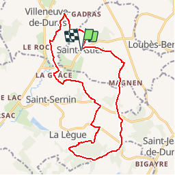
Trail Equestrian of 19 km to be discovered at New Aquitaine, Lot-et-Garonne, Saint-Astier. This trail is proposed by tracegps.

Description

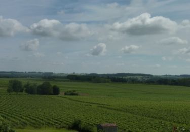
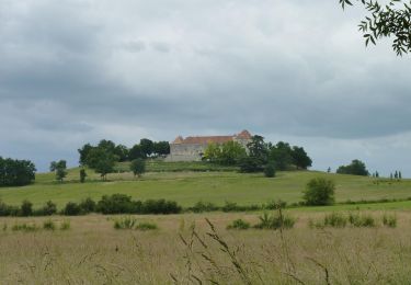
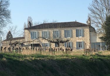
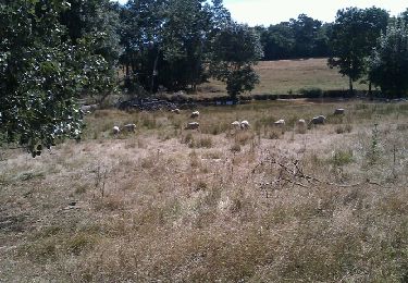
Saint Astier de Duras Communauté de Communes du Pays de Duras. Cette longue randonnée qui passe successivement sur les communes de St-Astier, Villeneuve, St-Sernin et St-Jean traverse les vignes A.O.C. des côtes de Duras mais aussi de nombreux vergers de pruniers d’Ente qui produisent le fameux pruneau d’Agen. Téléchargez la fiche de cette randonnée sur le site du Tourisme du Lot et Garonne.

Elevation profile

Photos

Positioning

Country:
France
Region :
New Aquitaine
Department/Province :
Lot-et-Garonne
Municipality :
Saint-Astier
Location:
Unknown
Start:(UTM)
282572 ; 4956459 (31T) N.

Trails nearby

Trail Walking Villeneuve-de-Duras - Villeneuve de D. - Photo
Walking
amelie14

Walking

Easy
(1)
Villeneuve-de-Duras, New Aquitaine, Lot-et-Garonne, France
16.5 km | 19.4 km-effort
3h 25min
Yes
Trail Walking Margueron - Randonnées à Margueron - Photo
Walking
tracegps

Walking

Medium
Margueron, New Aquitaine, Gironde, France
9.4 km | 10.9 km-effort
2h 30min
Yes
Trail Equestrian Villeneuve-de-Duras - Saint-Léger, entre bois, vignes et vergers de pruniers - Photo
Equestrian
tracegps

Equestrian

Easy
Villeneuve-de-Duras, New Aquitaine, Lot-et-Garonne, France
10.4 km | 12.3 km-effort
1h 45min
Yes
Trail Mountain bike Villeneuve-de-Duras - Saint-Léger, entre bois, vignes et vergers de pruniers - Photo
Mountain bike
tracegps

Mountain bike

Easy
Villeneuve-de-Duras, New Aquitaine, Lot-et-Garonne, France
10.4 km | 12.3 km-effort
1h 15min
Yes
Trail Walking Villeneuve-de-Duras - Saint-Léger, entre bois, vignes et vergers de pruniers - Photo
Walking
tracegps

Walking

Medium
Villeneuve-de-Duras, New Aquitaine, Lot-et-Garonne, France
10.4 km | 12.3 km-effort
2h 40min
Yes
Trail On foot Loubès-Bernac - FR-PR - Photo
On foot
PRO

On foot

Easy
Loubès-Bernac, New Aquitaine, Lot-et-Garonne, France
3.8 km | 4.7 km-effort
1h 3min
No
Trail Walking Villeneuve-de-Duras - Saint leger - Photo
Walking
Briarwood

Walking

Medium
Villeneuve-de-Duras, New Aquitaine, Lot-et-Garonne, France
10.4 km | 12.2 km-effort
2h 29min
Yes
Trail Walking Saint-Sernin - Lubersac - Photo
Walking
Briarwood

Walking

Easy
Saint-Sernin, New Aquitaine, Lot-et-Garonne, France
5.9 km | 7.3 km-effort
1h 50min
Yes
Trail Mountain bike Saint-Sernin - castel gaillard - Photo
Mountain bike
fishmamsk8

Mountain bike

Easy
Saint-Sernin, New Aquitaine, Lot-et-Garonne, France
12 km | 14.5 km-effort
1h 13min
Yes


Close
My subscriptions