Trail Mountain bike Gramont - Gramont - Balade des hameaux - Photo

Gramont - Balade des hameaux

 tracegps
tracegps

User

© OpenStreetMap contributors
Length
Length
4.5 km
Max alt
Max alt
182 m
Uphill gradient
Uphill gradient
82 m
Km-Effort
Km-Effort  
5.6 km
Min alt
Min alt
111 m
Downhill gradient
Downhill gradient
81 m
Boucle
Boucle
Yes
Creation date :
2014-12-10 00:00:00.0
Updated on :
2014-12-10 00:00:00.0

(0 Reviews)

Mountain bike
Mountain bike
19m
Difficulty : Easy

Scan this QR Code to open this trail in the SityTrail application

FREE GPS app for hiking

Logo SityTrail SityTrail

IGN / Geographical institutes

Download SityTrail from the App Store Download SityTrail from Google Play

Logo SityTrail SityTrail World

The world is yours!

Download SityTrail from the App Store Download SityTrail from Google Play Download SityTrail on Huawei AppGallery

About

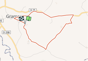
Trail Mountain bike of 4.5 km to be discovered at Occitania, Tarn-et-Garonne, Gramont. This trail is proposed by tracegps.

Description

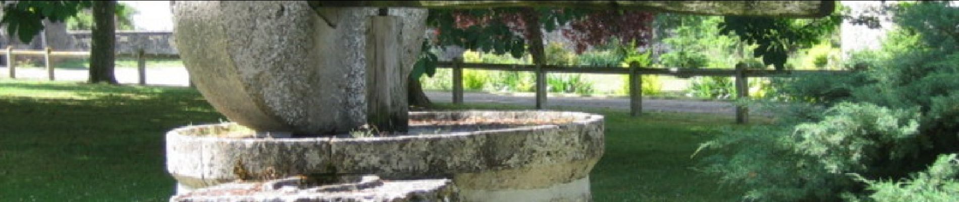
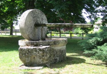
Gramont tout en pierre blanche allie histoire, patrimoine, terroir et gastronomie. Sur les coteaux de Lomagne, situé sur un éperon rocheux, Gramont domine la vallée de l'Arratz, un affluent de la Garonne. A voir en chemin -Château -Musée -Puits -Paysages -Moulin à huile -Travail -Belles demeures en pierre blanche. Retrouvez la fiche de cette randonnée sur le site de l’Office de Tourisme Intercommunal de la Lomagne Tarn et Garonnaise. Crédit-Photo : ©OTI Lomagne-G.Cassaro

Elevation profile

Photos

Positioning

Country:
France
Region :
Occitania
Department/Province :
Tarn-et-Garonne
Municipality :
Gramont
Location:
Unknown
Start:(UTM)
321091 ; 4867096 (31T) N.

Trails nearby

Trail Walking Saint-Clar - PR10 - Photo
Walking
mvh47

Walking

Very easy
(1)
Saint-Clar, Occitania, Gers, France
26 km | 35 km-effort
7h 20min
No
Trail Walking Gramont - Gramont - Balade des hameaux - Photo
Walking
tracegps

Walking

Medium
Gramont, Occitania, Tarn-et-Garonne, France
4.5 km | 5.6 km-effort
1h 15min
Yes
Trail Walking Castet-Arrouy - Etape Castet-Arrouy à Marsolan - Photo
Walking
marcel.F

Walking

Medium
Castet-Arrouy, Occitania, Gers, France
21 km | 26 km-effort
5h 31min
No
Trail Walking Castet-Arrouy - Saint Jacques Etape 24 - Photo
Walking
Jean-MarieFaux

Walking

Very easy
Castet-Arrouy, Occitania, Gers, France
21 km | 26 km-effort
5h 35min
No
Trail Walking Saint-Clar - PR10 - Photo
Walking
mvh47

Walking

Very easy
Saint-Clar, Occitania, Gers, France
26 km | 35 km-effort
7h 22min
No
Trail Walking Saint-Clar - PR10 - Photo
Walking
mvh47

Walking

Very easy
Saint-Clar, Occitania, Gers, France
26 km | 35 km-effort
7h 20min
No
Trail Walking Saint-Clar - PR10+equi - Photo
Walking
mvh47

Walking

Very easy
Saint-Clar, Occitania, Gers, France
199 km | 242 km-effort
10h 20min
No
Trail Walking Marsac - Marsac - Photo
Walking
sidore

Walking

Medium
Marsac, Occitania, Tarn-et-Garonne, France
5.5 km | 7.1 km-effort
1h 15min
Yes
Trail Walking Castet-Arrouy - Marsolan - Photo
Walking
Patmilord

Walking

Very difficult
Castet-Arrouy, Occitania, Gers, France
22 km | 27 km-effort
5h 9min
No


Close
My subscriptions