Trail Walking Tocane-Saint-Apre - Tocane Sud-Est - Photo
 swp648
swp648

User

© OpenStreetMap contributors
Length
Length
12.4 km
Max alt
Max alt
203 m
Uphill gradient
Uphill gradient
166 m
Km-Effort
Km-Effort  
14.6 km
Min alt
Min alt
75 m
Downhill gradient
Downhill gradient
166 m
Boucle
Boucle
Yes
Creation date :
2019-01-15 20:47:26.251
Updated on :
2019-01-15 20:47:26.251

(0 Reviews)

Walking
Walking
3h11
Difficulty : Unknown

Scan this QR Code to open this trail in the SityTrail application

FREE GPS app for hiking

Logo SityTrail SityTrail

IGN / Geographical institutes

Download SityTrail from the App Store Download SityTrail from Google Play

Logo SityTrail SityTrail World

The world is yours!

Download SityTrail from the App Store Download SityTrail from Google Play Download SityTrail on Huawei AppGallery

About

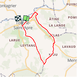
Trail Walking of 12.4 km to be discovered at New Aquitaine, Dordogne, Tocane-Saint-Apre. This trail is proposed by swp648.

Description

Départ place de l'église de Tocane-Saint-Apre en Dordogne.

Elevation profile

Positioning

Country:
France
Region :
New Aquitaine
Department/Province :
Dordogne
Municipality :
Tocane-Saint-Apre
Location:
Unknown
Start:(UTM)
303562 ; 5014211 (31T) N.

Trails nearby

Trail Walking Saint-Victor - 24 Boucle de Saint-Victor  - Photo
Walking
Patxito

Walking

Easy
(1)
Saint-Victor, New Aquitaine, Dordogne, France
11.7 km | 16.1 km-effort
3h 24min
Yes
Trail Walking Lisle - La boucle de Lisle - Photo
Walking
alainjoseph6

Walking

Medium
Lisle, New Aquitaine, Dordogne, France
9.9 km | 13.3 km-effort
3h 3min
Yes
Trail Walking Grand-Brassac - Mardi 06-06-2023 Grand Brassac via Montagrier - Photo
Walking
CASAURANCQ

Walking

Difficult
Grand-Brassac, New Aquitaine, Dordogne, France
10.1 km | 13.8 km-effort
3h 7min
Yes
Trail Walking Montagrier - 2023-03-10_16h37m21_joyeux-randonneurs-a-montagrier-2 - Photo
Walking
swp648

Walking

Difficult
(1)
Montagrier, New Aquitaine, Dordogne, France
10.7 km | 14.5 km-effort
3h 18min
Yes
Trail Walking Mensignac - Boucle de Mensignac - Photo
Walking
CC.RIDER

Walking

Difficult
Mensignac, New Aquitaine, Dordogne, France
13.6 km | 16.6 km-effort
3h 46min
Yes
Trail Walking Montagrier - montagrier - Photo
Walking
ANNIEXAVE

Walking

Medium
Montagrier, New Aquitaine, Dordogne, France
10.5 km | 14.2 km-effort
2h 33min
Yes
Trail Walking Lisle - Lisle Lisle 12km - Photo
Walking
YV24

Walking

Easy
Lisle, New Aquitaine, Dordogne, France
11.7 km | 15.9 km-effort
3h 25min
Yes
Trail Walking Grand-Brassac - grand brassac - Photo
Walking
descardm

Walking

Difficult
Grand-Brassac, New Aquitaine, Dordogne, France
10.6 km | 14.2 km-effort
2h 36min
Yes
Trail Walking Mensignac - Mensignac Fort Tuilier 9,8 km - Photo
Walking
descardm

Walking

Difficult
Mensignac, New Aquitaine, Dordogne, France
9.9 km | 12.5 km-effort
2h 49min
Yes


Close
My subscriptions