Trail Running Carsan - Courir à Carsan - Photo

Courir à Carsan

 tracegps
tracegps

User

© OpenStreetMap contributors
Length
Length
10.4 km
Max alt
Max alt
273 m
Uphill gradient
Uphill gradient
281 m
Km-Effort
Km-Effort  
14.1 km
Min alt
Min alt
131 m
Downhill gradient
Downhill gradient
277 m
Boucle
Boucle
Yes
Creation date :
2014-12-10 00:00:00.0
Updated on :
2014-12-10 00:00:00.0

(1 Reviews)

Running
Running
1h00
Difficulty : Difficult

Scan this QR Code to open this trail in the SityTrail application

FREE GPS app for hiking

Logo SityTrail SityTrail

IGN / Geographical institutes

Download SityTrail from the App Store Download SityTrail from Google Play

Logo SityTrail SityTrail World

The world is yours!

Download SityTrail from the App Store Download SityTrail from Google Play Download SityTrail on Huawei AppGallery

About

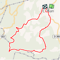
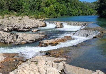
Trail Running of 10.4 km to be discovered at Occitania, Gard, Carsan. This trail is proposed by tracegps.

Description

Course nature, parfois monotrace, vallonnée.

Elevation profile

Positioning

Country:
France
Region :
Occitania
Department/Province :
Gard
Municipality :
Carsan
Location:
Unknown
Start:(UTM)
627245 ; 4899496 (31T) N.

Comments

Please log in to post a review or rate the element


jolie rando. Jolis sentiers en sous bois. Ne pas manquer de faire un aller-retour au lac de La Valbonne.


Trails nearby

Trail Walking Saint-Paulet-de-Caisson - Valbonne botaniques - Photo
Walking
raivavae

Walking

Easy
(1)
Saint-Paulet-de-Caisson, Occitania, Gard, France
3.3 km | 4.4 km-effort
56min
Yes
Trail Walking Saint-Paulet-de-Caisson - PF-Chartreuse de Valbonne - Photo
Walking
MicDul

Walking

Medium
(1)
Saint-Paulet-de-Caisson, Occitania, Gard, France
14.9 km | 21 km-effort
4h 24min
Yes
Trail Walking Vénéjan - 30 venejean - Photo
Walking
GUIDE
randodyssée

Walking

Medium
Vénéjan, Occitania, Gard, France
23 km | 29 km-effort
7h 11min
Yes
Trail Mountain bike Saint-Alexandre - Alexandrine 2007 (20 km) - Photo
Mountain bike
tracegps

Mountain bike

Difficult
(1)
Saint-Alexandre, Occitania, Gard, France
18.7 km | 25 km-effort
1h 45min
Yes
Trail Walking Vénéjan - Vénéjean Chateau de Gicon - Photo
Walking
GUIDE
nadinebondoux

Walking

Medium
Vénéjan, Occitania, Gard, France
16.5 km | 21 km-effort
4h 27min
Yes
Trail Walking Saint-Michel-d'Euzet - Les Cascades du Sautadet par Saint Michel d’Euzet - Photo
Walking
boudpn

Walking

Saint-Michel-d'Euzet, Occitania, Gard, France
16 km | 19.9 km-effort
5h 33min
Yes
Trail Walking Saint-Michel-d'Euzet - PF-Saint-Michel-d'Euzet - La Roque-sur-Cèze - Cascade du Sautadet - Photo
Walking
MicDul

Walking

Medium
(1)
Saint-Michel-d'Euzet, Occitania, Gard, France
13.7 km | 17.2 km-effort
3h 39min
No
Trail Walking Saint-Michel-d'Euzet - PF-Saint-Michel-d'Euzet - La Roque-sur-Cèze - Les Cascades du Sautadet - Photo
Walking
MicDul

Walking

Medium
Saint-Michel-d'Euzet, Occitania, Gard, France
8.8 km | 10.6 km-effort
2h 18min
Yes
Trail On foot Saint-Michel-d'Euzet - Randonnée du 12/06/2024 à 09:55 - Photo
On foot
Bcomb

On foot

Easy
Saint-Michel-d'Euzet, Occitania, Gard, France
7.5 km | 8.8 km-effort
1h 59min
Yes


Close
My subscriptions