Trail Walking Dauphin - De Dauphin vers la Forêt de Pélissier - Photo

De Dauphin vers la Forêt de Pélissier

 tracegps
tracegps

User

© OpenStreetMap contributors
Length
Length
9.8 km
Max alt
Max alt
762 m
Uphill gradient
Uphill gradient
396 m
Km-Effort
Km-Effort  
15.1 km
Min alt
Min alt
380 m
Downhill gradient
Downhill gradient
395 m
Boucle
Boucle
Yes
Creation date :
2014-12-10 00:00:00.0
Updated on :
2014-12-10 00:00:00.0

(0 Reviews)

Walking
Walking
3h30
Difficulty : Medium

Scan this QR Code to open this trail in the SityTrail application

FREE GPS app for hiking

Logo SityTrail SityTrail

IGN / Geographical institutes

Download SityTrail from the App Store Download SityTrail from Google Play

Logo SityTrail SityTrail World

The world is yours!

Download SityTrail from the App Store Download SityTrail from Google Play Download SityTrail on Huawei AppGallery

About

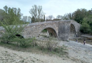
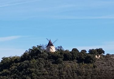
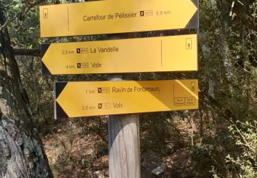
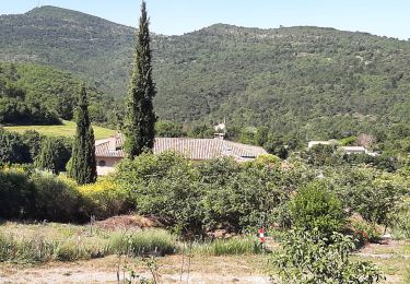
Trail Walking of 9.8 km to be discovered at Provence-Alpes-Côte d'Azur, Alpes-de-Haute-Provence, Dauphin. This trail is proposed by tracegps.

Description

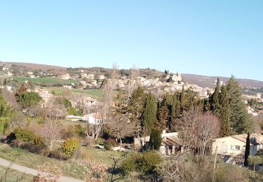
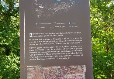
Départ au pied du village de Dauphin pour monter vers le Domaine de la Forêt de Pélissier. Déjeuner pris sur l'aire de Pique-nique de Bellevue. Retour vers Dauphin par l'autre versant.

Elevation profile

Photos

Positioning

Country:
France
Region :
Provence-Alpes-Côte d'Azur
Department/Province :
Alpes-de-Haute-Provence
Municipality :
Dauphin
Location:
Unknown
Start:(Dec)
Start:(UTM)
723145 ; 4863674 (31T) N.

Trails nearby

Trail Walking Manosque - Le Val des Chats, avant le col de la Mort d'Imbert. - Photo
Walking
liocol

Walking

Easy
(2)
Manosque, Provence-Alpes-Côte d'Azur, Alpes-de-Haute-Provence, France
4.7 km | 6.5 km-effort
1h 23min
Yes
Trail Mountain bike Volx - Volx/Montaigu/Bellevue/La Garde - Photo
Mountain bike
remizzi

Mountain bike

Medium
(1)
Volx, Provence-Alpes-Côte d'Azur, Alpes-de-Haute-Provence, France
16.2 km | 24 km-effort
1h 33min
Yes
Trail Walking Mane - mane le barrage - Photo
Walking
Roger

Walking

Medium
Mane, Provence-Alpes-Côte d'Azur, Alpes-de-Haute-Provence, France
11.5 km | 16.5 km-effort
4h 42min
Yes
Trail Walking Saint-Michel-l'Observatoire - st.michel l observatoire. les deux chapelles.  - Photo
Walking
Roger

Walking

Very easy
Saint-Michel-l'Observatoire, Provence-Alpes-Côte d'Azur, Alpes-de-Haute-Provence, France
4 km | 5.2 km-effort
1h 19min
Yes
Trail Walking Mane - salagon 04 .mane 04 leS - Photo
Walking
Roger

Walking

Medium
Mane, Provence-Alpes-Côte d'Azur, Alpes-de-Haute-Provence, France
13.4 km | 18 km-effort
4h 37min
Yes
Trail Walking Saint-Michel-l'Observatoire - Saint Michel l'observatoire - Photo
Walking
liocol

Walking

Easy
(1)
Saint-Michel-l'Observatoire, Provence-Alpes-Côte d'Azur, Alpes-de-Haute-Provence, France
6.1 km | 7.9 km-effort
2h 3min
Yes
Trail Trail Volx - volx - Photo
Trail
francislassauce

Trail

Difficult
Volx, Provence-Alpes-Côte d'Azur, Alpes-de-Haute-Provence, France
9.2 km | 14.7 km-effort
1h 43min
Yes
Trail Walking Saint-Michel-l'Observatoire - de Saint Martin les eaux à biabaux . la chapelle de hurage - Photo
Walking
Roger

Walking

Easy
Saint-Michel-l'Observatoire, Provence-Alpes-Côte d'Azur, Alpes-de-Haute-Provence, France
9.4 km | 13.1 km-effort
2h 51min
Yes
Trail Walking Saint-Martin-les-Eaux - 1Domaine de Bourne - Photo
Walking
liocol

Walking

Medium
Saint-Martin-les-Eaux, Provence-Alpes-Côte d'Azur, Alpes-de-Haute-Provence, France
5.6 km | 8.3 km-effort
2h 2min
Yes


Close
My subscriptions