Trail Mountain bike Campuac - Site VTT FFC - Gorges Lot et Truyère - Circuit n°1 Les Deux Clochers - Photo

Site VTT FFC - Gorges Lot et Truyère - Circuit n°1 Les Deux Clochers

 tracegps
tracegps

User

© OpenStreetMap contributors
Length
Length
25 km
Max alt
Max alt
680 m
Uphill gradient
Uphill gradient
518 m
Km-Effort
Km-Effort  
31 km
Min alt
Min alt
507 m
Downhill gradient
Downhill gradient
519 m
Boucle
Boucle
Yes
Creation date :
2014-12-10 00:00:00.0
Updated on :
2014-12-10 00:00:00.0

(0 Reviews)

Mountain bike
Mountain bike
1h45
Difficulty : Difficult

Scan this QR Code to open this trail in the SityTrail application

FREE GPS app for hiking

Logo SityTrail SityTrail

IGN / Geographical institutes

Download SityTrail from the App Store Download SityTrail from Google Play

Logo SityTrail SityTrail World

The world is yours!

Download SityTrail from the App Store Download SityTrail from Google Play Download SityTrail on Huawei AppGallery

About

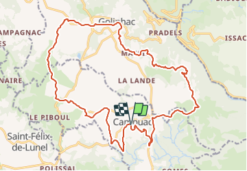
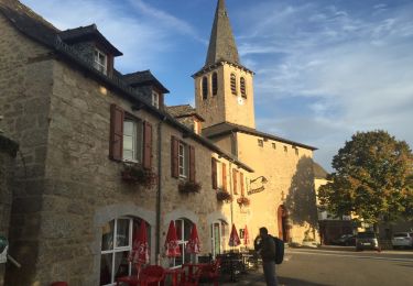
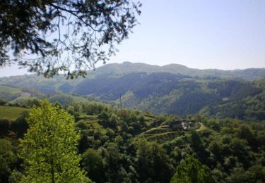
Trail Mountain bike of 25 km to be discovered at Occitania, Aveyron, Campuac. This trail is proposed by tracegps.

Description

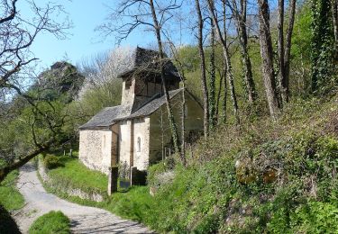
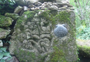
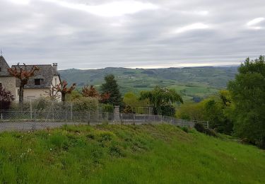
Possibilité départ de Campuac ou Golinhac (site VTT FFC). Parcours très mal balisé, car vieux panneaux effacés. Parcours légèrement modifié à la fin, entre Fonteilles et Campuac, car limite praticable (herbes très hautes). Superbes paysages par temps clair. Un petit portage de 50m vers le km 15. De superbes descentes en sous bois, gros cailloux, du pur régal vers km 18.

Elevation profile

Positioning

Country:
France
Region :
Occitania
Department/Province :
Aveyron
Municipality :
Campuac
Location:
Unknown
Start:(UTM)
467396 ; 4935046 (31T) N.

Trails nearby

Trail Walking Campuac - campuac - Photo
Walking
yves12

Walking

Medium
(1)
Campuac, Occitania, Aveyron, France
22 km | 32 km-effort
5h 8min
Yes
Trail Walking Golinhac - Massip Conques Avril 2018 - Photo
Walking
GUIDE
Kargil

Walking

Medium
Golinhac, Occitania, Aveyron, France
23 km | 31 km-effort
6h 6min
No
Trail On foot Campuac - Le Plateau de Campuac - Photo
On foot
PRO

On foot

Easy
Campuac, Occitania, Aveyron, France
7.6 km | 9 km-effort
2h 2min
No
Trail On foot Mouret - La Chapelle de Servières - Photo
On foot
PRO

On foot

Easy
Mouret, Occitania, Aveyron, France
5.6 km | 7.2 km-effort
1h 38min
No
Trail Walking Golinhac - CC_Velay_BE_09_Golinhac_Conques-Rouergue_20070824 - Photo
Walking
patrickdanilo

Walking

Medium
Golinhac, Occitania, Aveyron, France
20 km | 27 km-effort
5h 35min
No
Trail Walking Golinhac - golinhac conques  - Photo
Walking
guariso

Walking

Difficult
Golinhac, Occitania, Aveyron, France
24 km | 31 km-effort
6h 23min
No
Trail Walking Golinhac - golinhac - conques - Photo
Walking
jib971

Walking

Medium
Golinhac, Occitania, Aveyron, France
23 km | 31 km-effort
6h 43min
No
Trail Walking Golinhac - Golinhac - Vallée du Lot - Entraygues - Photo
Walking
tracegps

Walking

Difficult
Golinhac, Occitania, Aveyron, France
18.6 km | 28 km-effort
6h 30min
Yes
Trail sport Golinhac - Saint-Jacques, 2024, deux étape cinq - Photo
sport
ezola

sport

Very easy
Golinhac, Occitania, Aveyron, France
21 km | 28 km-effort
Unknown
No


Close
My subscriptions