Trail Mountain bike Tinchebray-Bocage - Vente Roulleaux, Le Tertre, Lonlay l'Abbaye - Photo

Vente Roulleaux, Le Tertre, Lonlay l'Abbaye

 tracegps
tracegps

User

© OpenStreetMap contributors
Length
Length
25 km
Max alt
Max alt
291 m
Uphill gradient
Uphill gradient
491 m
Km-Effort
Km-Effort  
32 km
Min alt
Min alt
144 m
Downhill gradient
Downhill gradient
482 m
Boucle
Boucle
No
Creation date :
2014-12-10 00:00:00.0
Updated on :
2014-12-10 00:00:00.0

(0 Reviews)

Mountain bike
Mountain bike
1h55
Difficulty : Medium

Scan this QR Code to open this trail in the SityTrail application

FREE GPS app for hiking

Logo SityTrail SityTrail

IGN / Geographical institutes

Download SityTrail from the App Store Download SityTrail from Google Play

Logo SityTrail SityTrail World

The world is yours!

Download SityTrail from the App Store Download SityTrail from Google Play Download SityTrail on Huawei AppGallery

About

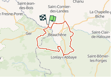
Trail Mountain bike of 25 km to be discovered at Normandy, Orne, Tinchebray-Bocage. This trail is proposed by tracegps.

Description

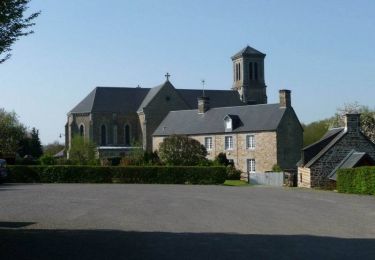
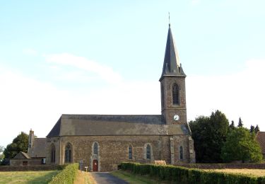
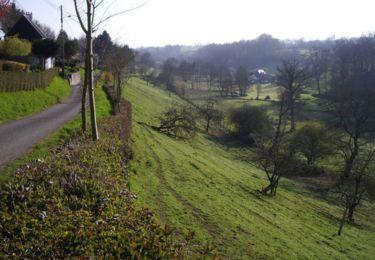
Circuit entre Beauchene et Lonlay l'Abbaye sur sentiers. Chemins bien tracés et assez bien encaissés même si en période hivernale, il y a de grandes chances pour que ce soit assez gras et collant. Quelques difficultés avec 3 ou 4 montées mais l'ensemble reste très agréable. Passage au Tertre, un des derniers (voir "le" dernier) domaines en France régit comme pendant le moyen age où la terre était en libre usage pour les gens y habitant. Après Lonlay, on emprunte un morceau de la voie romaine.

Elevation profile

Positioning

Country:
France
Region :
Normandy
Department/Province :
Orne
Municipality :
Tinchebray-Bocage
Location:
Beauchêne
Start:(UTM)
666035 ; 5395779 (30U) N.

Trails nearby

Trail Walking Tinchebray-Bocage - Chemin de l'Egrenne (n° 9) - Beauchêne  - Photo
Walking
tracegps

Walking

Medium
(1)
Tinchebray-Bocage, Normandy, Orne, France
11.2 km | 14.6 km-effort
2h 49min
Yes
Trail On foot Tinchebray-Bocage - Le Ruslé - Photo
On foot
GUIDE+

On foot

Easy
Tinchebray-Bocage, Normandy, Orne, France
5.4 km | 6.9 km-effort
1h 34min
No
Trail Walking Tinchebray-Bocage - Michelot Moulin - Pays de Tinchebray - Photo
Walking
tracegps

Walking

Medium
Tinchebray-Bocage, Normandy, Orne, France
12.4 km | 15.4 km-effort
3h 0min
Yes
Trail On foot Tinchebray-Bocage - Chemin de l'Egrenne - Photo
On foot
GUIDE+

On foot

Easy
Tinchebray-Bocage, Normandy, Orne, France
10.6 km | 14 km-effort
3h 10min
Yes
Trail Walking Tinchebray-Bocage - Le Ruslé  (n° 11)  - Yvrandes - Photo
Walking
tracegps

Walking

Easy
Tinchebray-Bocage, Normandy, Orne, France
5.7 km | 7.3 km-effort
1h 30min
Yes
Trail Mountain bike Tinchebray-Bocage - Boucle autour de Ger et de ses éoliennes - Photo
Mountain bike
tracegps

Mountain bike

Easy
Tinchebray-Bocage, Normandy, Orne, France
19.9 km | 25 km-effort
2h 30min
Yes
Trail Mountain bike Tinchebray-Bocage - Ger, Saint Jean des Bois, Yvrandes, Les Trois Cheminées - Photo
Mountain bike
tracegps

Mountain bike

Medium
Tinchebray-Bocage, Normandy, Orne, France
21 km | 27 km-effort
2h 30min
Yes
Trail Mountain bike Tinchebray-Bocage - Vente Roulleaux, Saint Jean des Bois, Le Fresne Poret - Photo
Mountain bike
tracegps

Mountain bike

Medium
Tinchebray-Bocage, Normandy, Orne, France
22 km | 27 km-effort
1h 49min
Yes
Trail Walking Tinchebray-Bocage - Petiteboucle à pied - La Vente Roulleau - Photo
Walking
tracegps

Walking

Medium
Tinchebray-Bocage, Normandy, Orne, France
3.1 km | 4.4 km-effort
30min
Yes


Close
My subscriptions