![](/images/other/stat-length.png)
![Trail Mountain bike Mamers - Au fil des chemins du Saosnois - Circuit n°5 - Photo](https://media.geolcdn.com/t/1900/400/ext.pjpeg?maxdim=2&url=https%3A%2F%2Fstatic1.geolcdn.com%2Fsiteimages%2Fupload%2Ffiles%2F1524743154velo.jpg)
Au fil des chemins du Saosnois - Circuit n°5
tracegps
User
![Length](/images/other/stat-length.png)
Length
28 km
![Max alt](https://static1.geolcdn.com/siteimages/upload/files/1508320355ic_sort_altitude_max_24dp.png)
Max alt
219 m
![Uphill gradient](https://static1.geolcdn.com/siteimages/upload/files/1508320355ic_sort_den_pos_24dp.png)
Uphill gradient
421 m
![Km-Effort](/images/other/stat-length.png)
Km-Effort
34 km
![Min alt](https://static1.geolcdn.com/siteimages/upload/files/1508320355ic_sort_altitude_min_24dp.png)
Min alt
102 m
![Downhill gradient](https://static1.geolcdn.com/siteimages/upload/files/1508320355ic_sort_den_neg_24dp.png)
Downhill gradient
419 m
![Boucle](https://static1.geolcdn.com/siteimages/upload/files/16400158638029165_repeat_loop_refresh_sync_direction_icon.png)
Boucle
Yes
Creation date :
2014-12-10 00:00:00.0
Updated on :
2014-12-10 00:00:00.0
![Mountain bike](https://static1.geolcdn.com/sitytour/trail-icons/202.png)
2h00
Difficulty : Medium
![Scan this QR Code to open this trail in the SityTrail application](https://capi.geolives.com/qq0zvz2zws4bq2lad0pu/sitytour/trails/105948/qr.png?size=200)
FREE GPS app for hiking
About
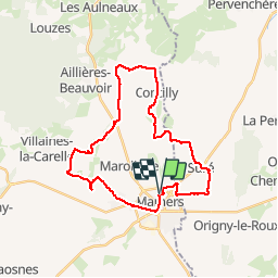
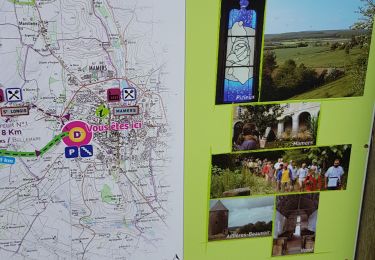
Trail Mountain bike of 28 km to be discovered at Pays de la Loire, Sarthe, Mamers. This trail is proposed by tracegps.
Description
Cette boucle débute de Mamers qui est une jolie bourgade avec un centre historique qui mérite le détour. Cette balade débute de la base de loisirs de la ville. Beaucoup de chemins à travers les champs et de tout petits bourgs. Quelques coins bien isolés. Pas de difficultés particulières.
Positioning
Country:
France
Region :
Pays de la Loire
Department/Province :
Sarthe
Municipality :
Mamers
Location:
Unknown
Start:(Dec)
Start:(UTM)
305327 ; 5359429 (31U) N.
Comments
Trails nearby
![Trail Walking Saint-Longis - voie verte - Photo](https://media.geolcdn.com/t/375/260/ext.jpg?maxdim=2&url=https%3A%2F%2Fmedia.geolcdn.com%2Ff%2Fd6d3a934-c6b6-4f4a-9b4c-4207a376a1ec.jpg)
![Walking Walking](https://static1.geolcdn.com/sitytour/trail-icons/101.png)
voie verte
Walking
Very easy
(1)
Saint-Longis,
Pays de la Loire,
Sarthe,
France
![](/images/other/stat-length.png)
8.5 km | 10 km-effort
2h 20min
![](https://static1.geolcdn.com/siteimages/upload/files/16400158638029165_repeat_loop_refresh_sync_direction_icon.png)
Yes
![Trail Walking Suré - suree - Photo](https://media.geolcdn.com/t/375/260/ext.jpg?maxdim=2&url=https%3A%2F%2Fstatic1.geolcdn.com%2Fsiteimages%2Fupload%2Ffiles%2F1553511878bg_sport_marche.png)
![Walking Walking](https://static1.geolcdn.com/sitytour/trail-icons/101.png)
![Trail Walking Contilly - Contilly 8,0 Km - Photo](https://media.geolcdn.com/t/375/260/ext.jpg?maxdim=2&url=https%3A%2F%2Fstatic1.geolcdn.com%2Fsiteimages%2Fupload%2Ffiles%2F1553511878bg_sport_marche.png)
![Walking Walking](https://static1.geolcdn.com/sitytour/trail-icons/101.png)
Contilly 8,0 Km
Walking
Easy
Contilly,
Pays de la Loire,
Sarthe,
France
![](/images/other/stat-length.png)
8 km | 9.3 km-effort
2h 3min
![](https://static1.geolcdn.com/siteimages/upload/files/16400158638029165_repeat_loop_refresh_sync_direction_icon.png)
Yes
![Trail Walking Mamers - mamers - Photo](https://media.geolcdn.com/t/375/260/ext.jpg?maxdim=2&url=https%3A%2F%2Fstatic1.geolcdn.com%2Fsiteimages%2Fupload%2Ffiles%2F1553511878bg_sport_marche.png)
![Walking Walking](https://static1.geolcdn.com/sitytour/trail-icons/101.png)
mamers
Walking
Very easy
Mamers,
Pays de la Loire,
Sarthe,
France
![](/images/other/stat-length.png)
4.6 km | 5.1 km-effort
2h 12min
![](https://static1.geolcdn.com/siteimages/upload/files/16400158638029165_repeat_loop_refresh_sync_direction_icon.png)
Yes
![Trail Walking Mamers - 2012-05-19 16h26m08 - Photo](https://media.geolcdn.com/t/375/260/ext.jpg?maxdim=2&url=https%3A%2F%2Fstatic1.geolcdn.com%2Fsiteimages%2Fupload%2Ffiles%2F1553511878bg_sport_marche.png)
![Walking Walking](https://static1.geolcdn.com/sitytour/trail-icons/101.png)
2012-05-19 16h26m08
Walking
Medium
Mamers,
Pays de la Loire,
Sarthe,
France
![](/images/other/stat-length.png)
24 km | 28 km-effort
5h 43min
![](https://static1.geolcdn.com/siteimages/upload/files/16400158638029165_repeat_loop_refresh_sync_direction_icon.png)
Yes