Trail Walking Ménessaire - Ménessaire - Photo
 tracegps
tracegps

User

© OpenStreetMap contributors
Length
Length
17.2 km
Max alt
Max alt
709 m
Uphill gradient
Uphill gradient
543 m
Km-Effort
Km-Effort  
24 km
Min alt
Min alt
389 m
Downhill gradient
Downhill gradient
543 m
Boucle
Boucle
Yes
Creation date :
2014-12-10 00:00:00.0
Updated on :
2014-12-10 00:00:00.0

(0 Reviews)

Walking
Walking
4h00
Difficulty : Medium

Scan this QR Code to open this trail in the SityTrail application

FREE GPS app for hiking

Logo SityTrail SityTrail

IGN / Geographical institutes

Download SityTrail from the App Store Download SityTrail from Google Play

Logo SityTrail SityTrail World

The world is yours!

Download SityTrail from the App Store Download SityTrail from Google Play Download SityTrail on Huawei AppGallery

About

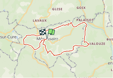
Trail Walking of 17.2 km to be discovered at Bourgogne-Franche-Comté, Côte-d'Or, Ménessaire. This trail is proposed by tracegps.

Description

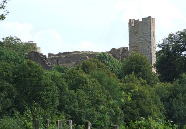
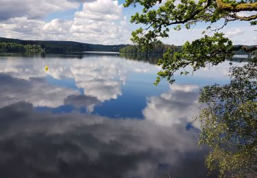
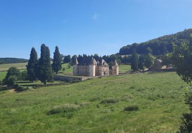
Ménessaire Distance : 18 km. Dénivelé : 500 m. Belle région très verdoyante. Quelques ruisseaux empruntent par endroit les sentiers. En tenir compte dans son équipement. Une randonnée du Club Alpin Français de l'Ouest Dijonnais. « Si tu veux aller un peu plus loin, avec le CAFOD tu feras des randonnées pas comme les autres» ! Avertissement : Les itinéraires mentionnés ici ne sont pas vérifiés (droit de passage, accidents de terrain, etc...). Par conséquent, il convient avant le départ de se renseigner sur la faisabilité du circuit envisagé.

Elevation profile

Photos

Positioning

Country:
France
Region :
Bourgogne-Franche-Comté
Department/Province :
Côte-d'Or
Municipality :
Ménessaire
Location:
Unknown
Start:(UTM)
586999 ; 5220816 (31T) N.

Trails nearby

Trail Running Moux-en-Morvan - moux 2 trail et mix - Photo
Running
dadodeca

Running

Medium
Moux-en-Morvan, Bourgogne-Franche-Comté, Nièvre, France
13 km | 18.4 km-effort
3h 24min
Yes
Trail Walking Moux-en-Morvan - Manu-161008 - Morvan-LacSettons - Photo
Walking
randodan

Walking

Very easy
Moux-en-Morvan, Bourgogne-Franche-Comté, Nièvre, France
18.3 km | 22 km-effort
5h 0min
Yes
Trail Walking Moux-en-Morvan - Marche Expérimentale Légion VIII Augusta - Anost - Saulieu - Photo
Walking
tracegps

Walking

Difficult
Moux-en-Morvan, Bourgogne-Franche-Comté, Nièvre, France
19 km | 24 km-effort
5h 0min
No
Trail Nordic walking Moux-en-Morvan - Settons - Photo
Nordic walking
PhJanet

Nordic walking

Easy
Moux-en-Morvan, Bourgogne-Franche-Comté, Nièvre, France
14.4 km | 16.4 km-effort
2h 39min
Yes
Trail Road bike Moux-en-Morvan - Lac des Settons - Photo
Road bike
PhilippeC54

Road bike

Medium
Moux-en-Morvan, Bourgogne-Franche-Comté, Nièvre, France
41 km | 50 km-effort
2h 32min
Yes
Trail Walking Moux-en-Morvan - 29 - MOUX-EN-MORVAN - IGM - Photo
Walking
nicolibris

Walking

Very easy
Moux-en-Morvan, Bourgogne-Franche-Comté, Nièvre, France
6.7 km | 9 km-effort
Unknown
Yes
Trail Walking Moux-en-Morvan - Tour du Morvan pédestre - de Moux à Saint Brisson  - Photo
Walking
tracegps

Walking

Difficult
Moux-en-Morvan, Bourgogne-Franche-Comté, Nièvre, France
28 km | 38 km-effort
7h 0min
No
Trail Horseback riding Cussy-en-Morvan - Cussy-Patuet-Menessaire-Montcimet - Photo
Horseback riding
IsaFal

Horseback riding

Medium
Cussy-en-Morvan, Bourgogne-Franche-Comté, Saône-et-Loire, France
20 km | 29 km-effort
3h 48min
Yes
Trail Horseback riding Cussy-en-Morvan - notre_dame_de_l_aillant_haut_du_chaumet-16620866-1715178085-577 - Photo
Horseback riding
IsaFal

Horseback riding

Medium
Cussy-en-Morvan, Bourgogne-Franche-Comté, Saône-et-Loire, France
22 km | 30 km-effort
3h 56min
No


Close
My subscriptions