Trail Mountain bike Lajoux - La Forestiere 2008  70km - Photo

La Forestiere 2008 70km

 tracegps
tracegps

User

© OpenStreetMap contributors
Length
Length
69 km
Max alt
Max alt
1253 m
Uphill gradient
Uphill gradient
1663 m
Km-Effort
Km-Effort  
94 km
Min alt
Min alt
544 m
Downhill gradient
Downhill gradient
2292 m
Boucle
Boucle
No
Creation date :
2014-12-10 00:00:00.0
Updated on :
2014-12-10 00:00:00.0

(0 Reviews)

Mountain bike
Mountain bike
5h00
Difficulty : Difficult

Scan this QR Code to open this trail in the SityTrail application

FREE GPS app for hiking

Logo SityTrail SityTrail

IGN / Geographical institutes

Download SityTrail from the App Store Download SityTrail from Google Play

Logo SityTrail SityTrail World

The world is yours!

Download SityTrail from the App Store Download SityTrail from Google Play Download SityTrail on Huawei AppGallery

About

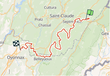
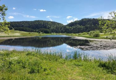
Trail Mountain bike of 69 km to be discovered at Bourgogne-Franche-Comté, Jura, Lajoux. This trail is proposed by tracegps.

Description

Edition du 21 Sept 2008 de La Forestière. Rando de 70 km de Lajoux à Arbent. Forestiere 2006 Th VTT envoyé par ThieracheVTT

Elevation profile

Positioning

Country:
France
Region :
Bourgogne-Franche-Comté
Department/Province :
Jura
Municipality :
Lajoux
Location:
Unknown
Start:(UTM)
728590 ; 5140232 (31T) N.

Trails nearby

Trail Walking Lamoura - Tresberruy - Lamoura - Photo
Walking
tracegps

Walking

Difficult
(1)
Lamoura, Bourgogne-Franche-Comté, Jura, France
14.5 km | 20 km-effort
4h 0min
Yes
Trail Cycle Lajoux - 2023-08-18_15h23m20_lamoura - Photo
Cycle
daniellebou

Cycle

Very easy
(1)
Lajoux, Bourgogne-Franche-Comté, Jura, France
21 km | 26 km-effort
Unknown
Yes
Trail Running Mijoux - UTTJ 2015-2 - Photo
Running
bourel.jacques

Running

Very difficult
(1)
Mijoux, Auvergne-Rhône-Alpes, Ain, France
57 km | 92 km-effort
18h 13min
No
Trail Walking Lajoux - crêt vigoureuse - Photo
Walking
eltonnermou

Walking

Medium
Lajoux, Bourgogne-Franche-Comté, Jura, France
12.3 km | 16.8 km-effort
5h 0min
Yes
Trail Walking Septmoncel les Molunes - Les Molunes - mairie  - Photo
Walking
jacno

Walking

Medium
(1)
Septmoncel les Molunes, Bourgogne-Franche-Comté, Jura, France
6.3 km | 8.4 km-effort
1h 54min
Yes
Trail Walking Gex - Balade à Col de la Faucille, Gex - Photo
Walking
Gaiato

Walking

Very difficult
Gex, Auvergne-Rhône-Alpes, Ain, France
86 km | 135 km-effort
9h 23min
No
Trail Bicycle tourism Mijoux - LES ROUSSES - COL DE LA FAUCILLE  - Photo
Bicycle tourism
jean-marie.parachini

Bicycle tourism

Very difficult
Mijoux, Auvergne-Rhône-Alpes, Ain, France
54 km | 68 km-effort
4h 57min
No
Trail Walking Lamoura - Autour Lamoura - Photo
Walking
swp648

Walking

Medium
Lamoura, Bourgogne-Franche-Comté, Jura, France
17.1 km | 25 km-effort
4h 37min
Yes
Trail Walking Bellecombe - Les Moussières - Photo
Walking
Greg813

Walking

Medium
Bellecombe, Bourgogne-Franche-Comté, Jura, France
21 km | 28 km-effort
5h 22min
Yes


Close
My subscriptions