Trail Mountain bike Duras - Ronde du Château de Duras - Photo

Ronde du Château de Duras

 tracegps
tracegps

User

© OpenStreetMap contributors
Length
Length
135 km
Max alt
Max alt
142 m
Uphill gradient
Uphill gradient
2237 m
Km-Effort
Km-Effort  
164 km
Min alt
Min alt
35 m
Downhill gradient
Downhill gradient
2235 m
Boucle
Boucle
Yes
Creation date :
2014-12-10 00:00:00.0
Updated on :
2014-12-10 00:00:00.0

(0 Reviews)

Mountain bike
Mountain bike
5h00
Difficulty : Very difficult

Scan this QR Code to open this trail in the SityTrail application

FREE GPS app for hiking

Logo SityTrail SityTrail

IGN / Geographical institutes

Download SityTrail from the App Store Download SityTrail from Google Play

Logo SityTrail SityTrail World

The world is yours!

Download SityTrail from the App Store Download SityTrail from Google Play Download SityTrail on Huawei AppGallery

About

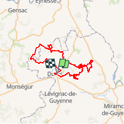
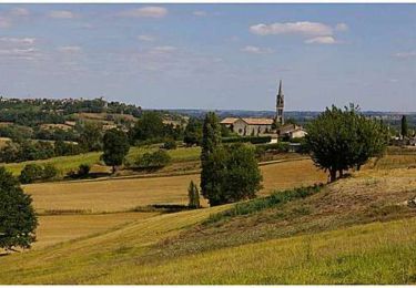
Trail Mountain bike of 135 km to be discovered at New Aquitaine, Lot-et-Garonne, Duras. This trail is proposed by tracegps.

Description

Le départ se fait depuis la salle de sport à Duras. Ca commence assez tranquille pour se mettre en condition pour le reste du circuit qui est une des plus belles randos et technique du Lot et Garonne. Il faut faire attention à ne pas partir trop vite pour ne pas se « cramer » au bout de 40 km, car le peu qui se fait sur route vous servira à récupérer pour enchaîner le reste !! Pour le terrain, on trouve pas mal de terre, des racines et quelques cailloux mais par contre, s’il pleut le terrain sèche assez vite, il suffit d'une journée pour pouvoir y rouler dessus. Cette rando est organisé tous les ans par le Vtt Club de Duras que je remercie d'ailleurs pour ce superbe tracé !

Elevation profile

Positioning

Country:
France
Region :
New Aquitaine
Department/Province :
Lot-et-Garonne
Municipality :
Duras
Location:
Unknown
Start:(UTM)
277119 ; 4950679 (31T) N.

Trails nearby

Trail Walking Baleyssagues - Balayssagues - Photo
Walking
Briarwood

Walking

Easy
Baleyssagues, New Aquitaine, Lot-et-Garonne, France
5.3 km | 6.4 km-effort
1h 34min
Yes
Trail Walking Saint-Sernin - Lubersac - Photo
Walking
Briarwood

Walking

Easy
Saint-Sernin, New Aquitaine, Lot-et-Garonne, France
5.9 km | 7.3 km-effort
1h 50min
Yes
Trail Mountain bike Duras - Ronde du Pruneau - Duras - Photo
Mountain bike
tracegps

Mountain bike

Difficult
Duras, New Aquitaine, Lot-et-Garonne, France
42 km | 51 km-effort
3h 30min
Yes
Trail Mountain bike Saint-Sernin - castel gaillard - Photo
Mountain bike
fishmamsk8

Mountain bike

Easy
Saint-Sernin, New Aquitaine, Lot-et-Garonne, France
12 km | 14.5 km-effort
1h 13min
Yes
Trail Cycle Duras - Circuit Vignes et Vergers en Duraquois - Photo
Cycle
tracegps

Cycle

Difficult
Duras, New Aquitaine, Lot-et-Garonne, France
102 km | 122 km-effort
5h 0min
Yes
Trail Mountain bike Saint-Sernin - Lubersac, une église de Saint-Sernin de Duras - Pays du Dropt - Photo
Mountain bike
tracegps

Mountain bike

Easy
Saint-Sernin, New Aquitaine, Lot-et-Garonne, France
5.4 km | 6.4 km-effort
40min
Yes
Trail Walking Saint-Sernin - Lubersac, une église de Saint-Sernin de Duras - Pays du Dropt - Photo
Walking
tracegps

Walking

Easy
Saint-Sernin, New Aquitaine, Lot-et-Garonne, France
5.4 km | 6.4 km-effort
2h 0min
Yes
Trail Walking Saint-Sernin - Saint-Sernin-de-Duras, la balade de Castelgaillard - Pays du Dropt - Photo
Walking
tracegps

Walking

Easy
Saint-Sernin, New Aquitaine, Lot-et-Garonne, France
4.4 km | 5.1 km-effort
1h 30min
Yes
Trail Equestrian Saint-Sernin - Saint-Sernin-de-Duras, vers le domaine d'Amblard - Pays du Dropt - Photo
Equestrian
tracegps

Equestrian

Medium
Saint-Sernin, New Aquitaine, Lot-et-Garonne, France
9.9 km | 11.9 km-effort
1h 40min
Yes


Close
My subscriptions