Névache, Hautes-Alpes, Miscellaneous: Best trails, routes and walks

33 comments

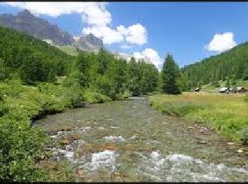
Névache: Discover the best trails: 2 fishing. All these trails, routes and outdoor activities are available in our SityTrail applications for smartphones and tablets.


The best trails (20)

Trail Other activity Névache - GR5  - Photo
Other activity 19.838
Km

Other activity

Difficult
Névache, Provence-Alpes-Côte d'Azur, Hautes-Alpes, France
19.8 km | 34 km-effort
7h 35min
1097 m
829 m
No
siggen

• Névache Mongenevre

Trail Other activity Névache - Pointe des Cerces . Circuit du lac rouge - Photo
Other activity 13.499
Km

Other activity

Difficult
Névache, Provence-Alpes-Côte d'Azur, Hautes-Alpes, France
13.5 km | 32 km-effort
7h 53min
1370 m
1369 m
Yes
nadd73

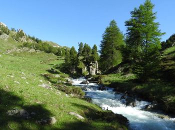
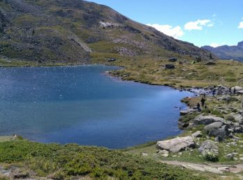
• Départ du dernier parking sur la route des Drayères. Passer la passerelle à gauche et monter au lac des Béraudes...

Trail Other activity Névache - la clareela  - Photo
Other activity 12.914
Km

Other activity

Very easy
Névache, Provence-Alpes-Côte d'Azur, Hautes-Alpes, France
12.9 km | 18.5 km-effort
6h 42min
380 m
539 m
No
avdem

• La claree 5 refuge laBuffere

Trail Other activity Névache - la claree 2 - Photo
Other activity 18.612
Km

Other activity

Very easy
Névache, Provence-Alpes-Côte d'Azur, Hautes-Alpes, France
18.6 km | 34 km-effort
10h 19min
1270 m
875 m
No
avdem

• la claree 2 Drayere

Trail Other activity Névache - La claree - Photo
Other activity 11.639
Km

Other activity

Very easy
Névache, Provence-Alpes-Côte d'Azur, Hautes-Alpes, France
11.6 km | 17.1 km-effort
4h 9min
369 m
536 m
No
avdem

• la claree 3 Refuge Laval

Trail Other activity Névache - pointe  du Bière.  Pic ombière. point 2418   - Photo
Other activity 15.629
Km

Other activity

Medium
Névache, Provence-Alpes-Côte d'Azur, Hautes-Alpes, France
15.6 km | 33 km-effort
9h 7min
1339 m
1340 m
Yes
nadd73

• départ sur la route des Drayeres vers la chapelle ste Marie. très belle randonnée et belle vallée

Trail Fishing Névache - GPS 05 La Clarée parcours 02 Avozzeto - Photo
Fishing 1.445
Km

Fishing

Easy
Névache, Provence-Alpes-Côte d'Azur, Hautes-Alpes, France
1.4 km | 1.8 km-effort
8h 0min
35 m
11 m
No
grassimo

Trail Fishing Névache - GPS 05 La Clarée parcours 01 Yannick rivière - Photo
Fishing 2.719
Km

Fishing

Easy
Névache, Provence-Alpes-Côte d'Azur, Hautes-Alpes, France
2.7 km | 4.2 km-effort
8h 0min
149 m
6 m
No
grassimo

Trail Other activity Névache - lacs laramon et serpent - Photo
Other activity 9.152
Km

Other activity

Very easy
Névache, Provence-Alpes-Côte d'Azur, Hautes-Alpes, France
9.2 km | 17.1 km-effort
3h 52min
596 m
596 m
Yes
gfk49

Trail Other activity Névache - Jour 1 - Photo
Other activity 16.284
Km

Other activity

Difficult
Névache, Provence-Alpes-Côte d'Azur, Hautes-Alpes, France
16.3 km | 31 km-effort
5h 0min
1343 m
439 m
No
abrun

Trail Other activity Névache - nevache un - Photo
Other activity 9.356
Km

Other activity

Very easy
Névache, Provence-Alpes-Côte d'Azur, Hautes-Alpes, France
9.4 km | 16.9 km-effort
5h 5min
616 m
423 m
No
avdem

• Nevache Refuge trois Alpini

Trail Other activity Névache - la claree - Photo
Other activity 9.249
Km

Other activity

Very easy
Névache, Provence-Alpes-Côte d'Azur, Hautes-Alpes, France
9.2 km | 14.6 km-effort
3h 58min
287 m
759 m
No
avdem

• fin9

Trail Other activity Névache - Rocher du Raisin - Photo
Other activity 5.35
Km

Other activity

Medium
Névache, Provence-Alpes-Côte d'Azur, Hautes-Alpes, France
5.3 km | 16 km-effort
3h 0min
1063 m
14 m
No
al1.carriere

Trail Other activity Névache - Thabor ski - Photo
Other activity 7.077
Km

Other activity

Medium
Névache, Provence-Alpes-Côte d'Azur, Hautes-Alpes, France
7.1 km | 21 km-effort
5h 0min
1420 m
30 m
No
lolo04

Trail Other activity Névache - Névache aux cascades - Photo
Other activity 7.921
Km

Other activity

Easy
Névache, Provence-Alpes-Côte d'Azur, Hautes-Alpes, France
7.9 km | 13 km-effort
6min
433 m
210 m
No
oliseb

Trail Other activity Névache - Untitled - Photo
Other activity 15.502
Km

Other activity

Difficult
Névache, Provence-Alpes-Côte d'Azur, Hautes-Alpes, France
15.5 km | 26 km-effort
8h 27min
804 m
805 m
Yes
davire48

Trail Other activity Névache - aiguille rouge  - Photo
Other activity 12.434
Km

Other activity

Very easy
Névache, Provence-Alpes-Côte d'Azur, Hautes-Alpes, France
12.4 km | 23 km-effort
6h 21min
763 m
918 m
No
colducaillou

Trail Other activity Névache - la clarée - Photo
Other activity 9.053
Km

Other activity

Very easy
Névache, Provence-Alpes-Côte d'Azur, Hautes-Alpes, France
9.1 km | 15.6 km-effort
5h 0min
602 m
173 m
No
ascq

Trail Other activity Névache - Raid ski Thabor J3 - Photo
Other activity 13.602
Km

Other activity

Very easy
Névache, Provence-Alpes-Côte d'Azur, Hautes-Alpes, France
13.6 km | 27 km-effort
5h 0min
958 m
1263 m
No
niko.persini

Trail Other activity Névache - buffère - col - chardonnet - Photo
Other activity 12.323
Km

Other activity

Medium
Névache, Provence-Alpes-Côte d'Azur, Hautes-Alpes, France
12.3 km | 25 km-effort
Unknown
968 m
829 m
No
giloucatou

20 trails displayed on 20

FREE GPS app for hiking

Logo SityTrail SityTrail

IGN / Geographical institutes

Download SityTrail from the App Store Download SityTrail from Google Play

Logo SityTrail SityTrail World

The world is yours!

Download SityTrail from the App Store Download SityTrail from Google Play Download SityTrail on Huawei AppGallery

Activities

Close
My subscriptions