![](/images/other/stat-length.png)
![Tour Wandern Causses-et-Veyran - Mont Peyroux (Causses et Veyran) - Photo](https://media.geolcdn.com/t/1900/400/ext.pjpeg?maxdim=2&url=https%3A%2F%2Fmedia.geolcdn.com%2Ff%2F9e8358e4-e82b-4fb9-ba94-ec7ad428195d.jpg)
Mont Peyroux (Causses et Veyran)
Raymond DAVID
Benutzer
![Länge](/images/other/stat-length.png)
Länge
14,4 km
![Maximale Höhe](https://static1.geolcdn.com/siteimages/upload/files/1508320355ic_sort_altitude_max_24dp.png)
Maximale Höhe
406 m
![Positive Höhendifferenz](https://static1.geolcdn.com/siteimages/upload/files/1508320355ic_sort_den_pos_24dp.png)
Positive Höhendifferenz
551 m
![Km-Effort](/images/other/stat-length.png)
Km-Effort
22 km
![Min. Höhe](https://static1.geolcdn.com/siteimages/upload/files/1508320355ic_sort_altitude_min_24dp.png)
Min. Höhe
112 m
![Negative Höhendifferenz](https://static1.geolcdn.com/siteimages/upload/files/1508320355ic_sort_den_neg_24dp.png)
Negative Höhendifferenz
551 m
![Boucle](https://static1.geolcdn.com/siteimages/upload/files/16400158638029165_repeat_loop_refresh_sync_direction_icon.png)
Boucle
Ja
Erstellungsdatum :
2023-05-07 07:04:33.149
Letzte Änderung :
2023-05-15 12:54:09.099
![Wandern](https://static1.geolcdn.com/sitytour/trail-icons/101.png)
5h30
Schwierigkeit : Schwierig
![Scannen Sie diesen QR-Code, um die Tour in der SityTrail-Anwendung zu öffnen](https://capi.geolives.com/qq0zvz2zws4bq2lad0pu/sitytour/trails/3660249/qr.png?size=200)
Kostenlosegpshiking-Anwendung
Über SityTrail
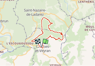
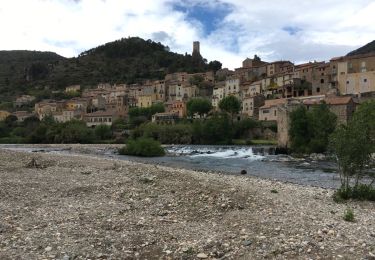
Tour Wandern von 14,4 km verfügbar auf Okzitanien, Hérault, Causses-et-Veyran. Diese Tour wird von Raymond DAVID vorgeschlagen.
Beschreibung
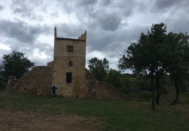
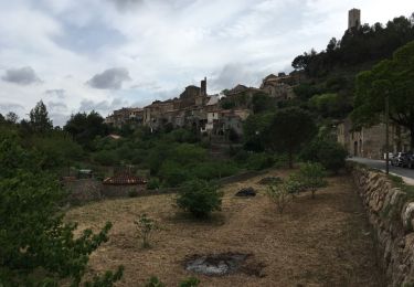
Parking mairie, à faire de préférence dans le sens anti-horaire, la dernière montée vers le mont Peyroux est courte mais très pentue, carrefour mal indiqué suivre le GPS.
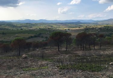
Randonnée à éviter en été, peu ombragée.
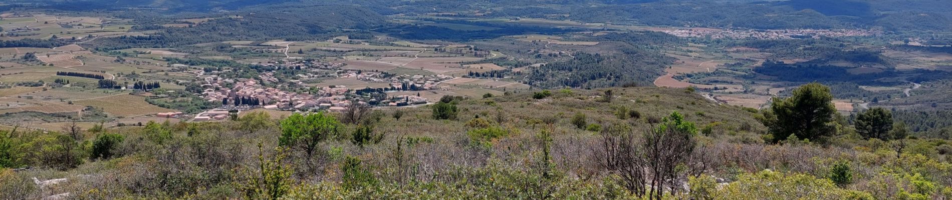
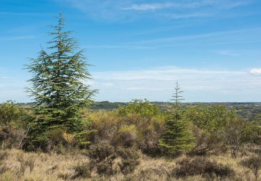
De beaux points de vue à 360 degrés
Ort
Land:
France
Region :
Okzitanien
Abteilung/Provinz :
Hérault
Kommune :
Causses-et-Veyran
Standort:
Unknown
Gehen Sie:(Dec)
Gehen Sie:(UTM)
506839 ; 4813628 (31T) N.
Kommentare
Touren in der Umgebung
![Tour Wandern Cessenon-sur-Orb - Cessenon Rives de l'Orb - Photo](https://media.geolcdn.com/t/375/260/ext.jpg?maxdim=2&url=https%3A%2F%2Fservices.sitytrail.com%2FGeolivesWS%2FDownloadMedia.ashx%3FTrailID%3D169953%26Media%3D04af9e60-af3a-487e-abf0-9064e60910a7.jpg)
![Wandern Wandern](https://static1.geolcdn.com/sitytour/trail-icons/101.png)
Cessenon Rives de l'Orb
Wandern
Einfach
(2)
Cessenon-sur-Orb,
Okzitanien,
Hérault,
France
![](/images/other/stat-length.png)
12,5 km | 14,4 km-effort
3h 11min
![](https://static1.geolcdn.com/siteimages/upload/files/16400158638029165_repeat_loop_refresh_sync_direction_icon.png)
Ja
![Tour Wandern Cessenon-sur-Orb - Reals et les gravieres de Savignac - Photo](https://media.geolcdn.com/t/375/260/ext.jpg?maxdim=2&url=https%3A%2F%2Fmedia.geolcdn.com%2Ff%2Fe021d63d-dae7-410a-86cc-306c98d678b2.jpg)
![Wandern Wandern](https://static1.geolcdn.com/sitytour/trail-icons/101.png)
Reals et les gravieres de Savignac
Wandern
Medium
Cessenon-sur-Orb,
Okzitanien,
Hérault,
France
![](/images/other/stat-length.png)
16,7 km | 20 km-effort
5h 0min
![](https://static1.geolcdn.com/siteimages/upload/files/16400158638029165_repeat_loop_refresh_sync_direction_icon.png)
Ja
![Tour Zu Fuß Murviel-lès-Béziers - Le Pech Belet - Circuit A - Photo](https://media.geolcdn.com/t/375/260/ext.jpg?maxdim=2&url=https%3A%2F%2Fmedia.geolcdn.com%2Ff%2F743b62e5-85cc-4253-bbec-04e46b08240b.jpeg)
![Zu Fuß Zu Fuß](https://static1.geolcdn.com/sitytour/trail-icons/100.png)
Le Pech Belet - Circuit A
Zu Fuß
Einfach
(1)
Murviel-lès-Béziers,
Okzitanien,
Hérault,
France
![](/images/other/stat-length.png)
3,4 km | 4,8 km-effort
1h 5min
![](https://static1.geolcdn.com/siteimages/upload/files/16400158638029165_repeat_loop_refresh_sync_direction_icon.png)
Ja
![Tour Wandern Murviel-lès-Béziers - Circuit le Pech Belet - Photo](https://media.geolcdn.com/t/375/260/ext.jpg?maxdim=2&url=https%3A%2F%2Fmedia.geolcdn.com%2Ff%2Fb7b0a420-355e-4089-aa69-499ac493404d.jpg)
![Wandern Wandern](https://static1.geolcdn.com/sitytour/trail-icons/101.png)
Circuit le Pech Belet
Wandern
Medium
Murviel-lès-Béziers,
Okzitanien,
Hérault,
France
![](/images/other/stat-length.png)
9,4 km | 11 km-effort
1h 2min
![](https://static1.geolcdn.com/siteimages/upload/files/16400158638029165_repeat_loop_refresh_sync_direction_icon.png)
Nein
![Tour Laufen Murviel-lès-Béziers - Circuit des Pigeonniers - Murviel-les-Béziers - Photo](https://media.geolcdn.com/t/375/260/ext.jpg?maxdim=2&url=https%3A%2F%2Fmedia.geolcdn.com%2Ff%2F8f370bf0-d8df-4db0-8234-c9ccf4c75882.jpg)
![Laufen Laufen](https://static1.geolcdn.com/sitytour/trail-icons/103.png)
Circuit des Pigeonniers - Murviel-les-Béziers
Laufen
Medium
(1)
Murviel-lès-Béziers,
Okzitanien,
Hérault,
France
![](/images/other/stat-length.png)
9,5 km | 11,6 km-effort
1h 20min
![](https://static1.geolcdn.com/siteimages/upload/files/16400158638029165_repeat_loop_refresh_sync_direction_icon.png)
Ja
![Tour Wandern Causses-et-Veyran - Causses-et-Veyran / Chaos de Réals (Gourniès) / Viranel / Combe longue - Photo](https://media.geolcdn.com/t/375/260/ext.jpg?maxdim=2&url=https%3A%2F%2Fmedia.geolcdn.com%2Ff%2F378a0b30-8552-4963-b3d1-65237cb2e100.jpg)
![Wandern Wandern](https://static1.geolcdn.com/sitytour/trail-icons/101.png)
Causses-et-Veyran / Chaos de Réals (Gourniès) / Viranel / Combe longue
Wandern
Medium
Causses-et-Veyran,
Okzitanien,
Hérault,
France
![](/images/other/stat-length.png)
13,3 km | 16,4 km-effort
4h 26min
![](https://static1.geolcdn.com/siteimages/upload/files/16400158638029165_repeat_loop_refresh_sync_direction_icon.png)
Ja
![Tour Wandern Causses-et-Veyran - Marche - Tour des Chaos dolomitiques de REALS - Photo](https://media.geolcdn.com/t/375/260/ext.jpg?maxdim=2&url=https%3A%2F%2Fservices.sitytrail.com%2FGeolivesWS%2FDownloadMedia.ashx%3FTrailID%3D951700%26Media%3Dfix__20180425185536.jpg)
![Wandern Wandern](https://static1.geolcdn.com/sitytour/trail-icons/101.png)
Marche - Tour des Chaos dolomitiques de REALS
Wandern
Medium
Causses-et-Veyran,
Okzitanien,
Hérault,
France
![](/images/other/stat-length.png)
5,5 km | 7,7 km-effort
1h 53min
![](https://static1.geolcdn.com/siteimages/upload/files/16400158638029165_repeat_loop_refresh_sync_direction_icon.png)
Ja
![Tour Wandern Roquebrun - roquebrun nord - Photo](https://media.geolcdn.com/t/375/260/ext.jpg?maxdim=2&url=https%3A%2F%2Fservices.sitytrail.com%2FGeolivesWS%2FDownloadMedia.ashx%3FTrailID%3D565590%26Media%3D20160507182104.jpg)
![Wandern Wandern](https://static1.geolcdn.com/sitytour/trail-icons/101.png)
roquebrun nord
Wandern
Einfach
(1)
Roquebrun,
Okzitanien,
Hérault,
France
![](/images/other/stat-length.png)
9,7 km | 14,3 km-effort
2h 58min
![](https://static1.geolcdn.com/siteimages/upload/files/16400158638029165_repeat_loop_refresh_sync_direction_icon.png)
Ja
![Tour Wandern Roquebrun - roquebrun sud - Photo](https://media.geolcdn.com/t/375/260/ext.jpg?maxdim=2&url=https%3A%2F%2Fservices.sitytrail.com%2FGeolivesWS%2FDownloadMedia.ashx%3FTrailID%3D562223%26Media%3D20160501141828.jpg)
![Wandern Wandern](https://static1.geolcdn.com/sitytour/trail-icons/101.png)
roquebrun sud
Wandern
Sehr leicht
Roquebrun,
Okzitanien,
Hérault,
France
![](/images/other/stat-length.png)
9 km | 12,1 km-effort
2h 35min
![](https://static1.geolcdn.com/siteimages/upload/files/16400158638029165_repeat_loop_refresh_sync_direction_icon.png)
Ja