Tour Laufen Toulonjac - Running de Toulonjac à Villeneuve - Photo

Running de Toulonjac à Villeneuve

 tracegps
tracegps

Benutzer

© OpenStreetMap contributors
Länge
Länge
25 km
Maximale Höhe
Maximale Höhe
416 m
Positive Höhendifferenz
590 m
Km-Effort
Km-Effort  
32 km
Min. Höhe
Min. Höhe
287 m
Negative Höhendifferenz
591 m
Boucle
Boucle
Ja
Erstellungsdatum :
2014-12-10 00:00:00.0
Letzte Änderung :
2014-12-10 00:00:00.0

(0 Nachricht)

Laufen
Laufen
2h30
Schwierigkeit : Medium

Scannen Sie diesen QR-Code, um die Tour in der SityTrail-Anwendung zu öffnen

Kostenlosegpshiking-Anwendung

Logo SityTrail SityTrail

IGN / Geografische Institute

SityTrail aus dem App Store herunterladen SityTrail von Google Play herunterladen

Logo SityTrail SityTrail World

Die Welt öffnet sich für Sie

SityTrail aus dem App Store herunterladen SityTrail von Google Play herunterladen SityTrail auf Huawei AppGallery herunterladen

Über SityTrail

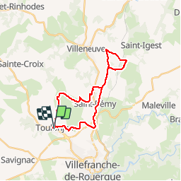
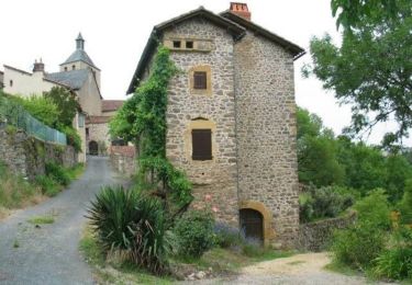
Tour Laufen von 25 km verfügbar auf Okzitanien, Aveyron, Toulonjac. Diese Tour wird von tracegps vorgeschlagen.

Beschreibung

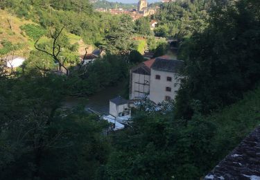
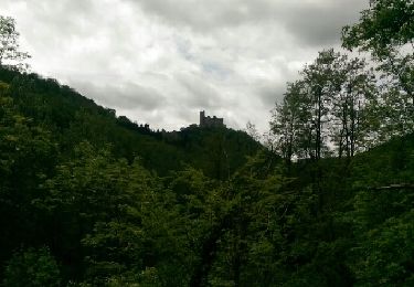
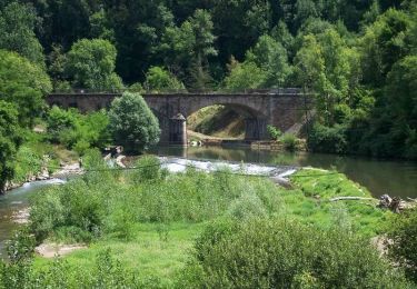
Bon parcours, bien roulant avec de beaux points de vue.

Höhenprofil

Foto-Galerie

Ort

Land:
France
Region :
Okzitanien
Abteilung/Provinz :
Aveyron
Kommune :
Toulonjac
Standort:
Unknown
Gehen Sie:(Dec)
Gehen Sie:(UTM)
420348 ; 4914709 (31T) N.

Touren in der Umgebung

Tour Hybrid-Bike Villefranche-de-Rouergue - VTC  Villefranche - Vailhourles  - Photo
Hybrid-Bike
Levillefranchois

Hybrid-Bike

Einfach
(1)
Villefranche-de-Rouergue, Okzitanien, Aveyron, France
32 km | 40 km-effort
Unbekannt
Ja
Tour Zu Fuß Sainte-Croix - Balade autour de Sainte-Croix - Circuit 1 - Photo
Zu Fuß
GUIDE+

Zu Fuß

Einfach
Sainte-Croix, Okzitanien, Aveyron, France
4,2 km | 5,3 km-effort
1h 12min
Ja
Tour Zu Fuß Sainte-Croix - Balade autour de Sainte-Croix - Circuit 3 - Photo
Zu Fuß
GUIDE+

Zu Fuß

Einfach
Sainte-Croix, Okzitanien, Aveyron, France
6,5 km | 8,1 km-effort
1h 50min
Ja
Tour Wandern Villefranche-de-Rouergue - villefranche de rouergue - Photo
Wandern
betf

Wandern

Einfach
(2)
Villefranche-de-Rouergue, Okzitanien, Aveyron, France
10,9 km | 15,3 km-effort
3h 19min
Ja
Tour Rennrad Villefranche-de-Rouergue - Gorges Aveyron - Photo
Rennrad
ALAIN3859

Rennrad

Schwierig
(1)
Villefranche-de-Rouergue, Okzitanien, Aveyron, France
29 km | 37 km-effort
2h 15min
Ja
Tour Wandern Villefranche-de-Rouergue - Villefranche de Rouergur - Photo
Wandern
richardsimopons

Wandern

Villefranche-de-Rouergue, Okzitanien, Aveyron, France
5,8 km | 8,2 km-effort
1h 26min
Ja
Tour Wandern Villefranche-de-Rouergue - Compostelle : 3-Villefranche-de-Rouergue - Najac - Photo
Wandern
prv

Wandern

Sehr leicht
Villefranche-de-Rouergue, Okzitanien, Aveyron, France
24 km | 32 km-effort
5h 53min
Nein
Tour Fahrrad Villefranche-de-Rouergue - Savoureuse balade au pays des bastides du Rouergue -  Villefranche de Rouergue - Photo
Fahrrad
tracegps

Fahrrad

Schwierig
Villefranche-de-Rouergue, Okzitanien, Aveyron, France
60 km | 78 km-effort
3h 49min
Ja
Tour Fahrrad Villefranche-de-Rouergue - Circuit de Villefranche de Rouergue - Foissac - Photo
Fahrrad
tracegps

Fahrrad

Schwierig
Villefranche-de-Rouergue, Okzitanien, Aveyron, France
76 km | 93 km-effort
5h 49min
Ja


Schließen
Meine Abonnements