![](/images/other/stat-length.png)
![Tour Mountainbike Veauche - Pierre de Bauche 32 km - Photo](https://media.geolcdn.com/t/1900/400/ext.pjpeg?maxdim=2&url=https%3A%2F%2Fstatic1.geolcdn.com%2Fsiteimages%2Fupload%2Ffiles%2F1524743154velo.jpg)
Pierre de Bauche 32 km
Xavier42
Benutzer
![Länge](/images/other/stat-length.png)
Länge
32 km
![Maximale Höhe](https://static1.geolcdn.com/siteimages/upload/files/1508320355ic_sort_altitude_max_24dp.png)
Maximale Höhe
873 m
![Positive Höhendifferenz](https://static1.geolcdn.com/siteimages/upload/files/1508320355ic_sort_den_pos_24dp.png)
Positive Höhendifferenz
680 m
![Km-Effort](/images/other/stat-length.png)
Km-Effort
41 km
![Min. Höhe](https://static1.geolcdn.com/siteimages/upload/files/1508320355ic_sort_altitude_min_24dp.png)
Min. Höhe
382 m
![Negative Höhendifferenz](https://static1.geolcdn.com/siteimages/upload/files/1508320355ic_sort_den_neg_24dp.png)
Negative Höhendifferenz
682 m
![Boucle](https://static1.geolcdn.com/siteimages/upload/files/16400158638029165_repeat_loop_refresh_sync_direction_icon.png)
Boucle
Ja
Erstellungsdatum :
2020-07-08 12:24:47.653
Letzte Änderung :
2020-07-08 12:27:08.761
![Mountainbike](https://static1.geolcdn.com/sitytour/trail-icons/202.png)
2h39
Schwierigkeit : Schwierig
![Scannen Sie diesen QR-Code, um die Tour in der SityTrail-Anwendung zu öffnen](https://capi.geolives.com/qq0zvz2zws4bq2lad0pu/sitytour/trails/2466859/qr.png?size=200)
Kostenlosegpshiking-Anwendung
Über SityTrail
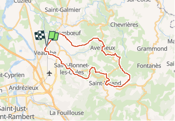
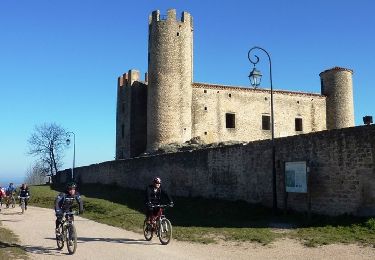
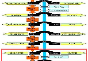
Tour Mountainbike von 32 km verfügbar auf Auvergne-Rhone-Alpen, Loire, Veauche. Diese Tour wird von Xavier42 vorgeschlagen.
Beschreibung
Boucle au départ de la gare de Veauche pour grimper aux antennes au dessus de Saint Héand
Ort
Land:
France
Region :
Auvergne-Rhone-Alpen
Abteilung/Provinz :
Loire
Kommune :
Veauche
Standort:
Unknown
Gehen Sie:(Dec)
Gehen Sie:(UTM)
600899 ; 5046640 (31T) N.
Kommentare
Touren in der Umgebung
![Tour Wandern Andrézieux-Bouthéon - autour de Boutheon - Photo](https://media.geolcdn.com/t/375/260/ext.jpg?maxdim=2&url=https%3A%2F%2Fmedia.geolcdn.com%2Ff%2F2650ae89-7750-43af-bfc7-bc43f795b3df.jpg)
![Wandern Wandern](https://static1.geolcdn.com/sitytour/trail-icons/101.png)
autour de Boutheon
Wandern
Sehr leicht
Andrézieux-Bouthéon,
Auvergne-Rhone-Alpen,
Loire,
France
![](/images/other/stat-length.png)
7,6 km | 8,7 km-effort
1h 46min
![](https://static1.geolcdn.com/siteimages/upload/files/16400158638029165_repeat_loop_refresh_sync_direction_icon.png)
Ja
![Tour Mountainbike Veauche - Par Monts et par Veauche (2014-VTT-70km) - Veauche - Photo](https://media.geolcdn.com/t/375/260/ext.jpg?maxdim=2&url=https%3A%2F%2Fservices.sitytrail.com%2FGeolivesWS%2FDownloadMedia.ashx%3FTrailID%3D318103%26Media%3D17562_6.jpg)
![Mountainbike Mountainbike](https://static1.geolcdn.com/sitytour/trail-icons/202.png)
Par Monts et par Veauche (2014-VTT-70km) - Veauche
Mountainbike
Sehr schwierig
Veauche,
Auvergne-Rhone-Alpen,
Loire,
France
![](/images/other/stat-length.png)
69 km | 90 km-effort
6h 0min
![](https://static1.geolcdn.com/siteimages/upload/files/16400158638029165_repeat_loop_refresh_sync_direction_icon.png)
Ja
![Tour Mountainbike Veauche - Par Monts et par Veauche (2014-VTT-45km) - Veauche - Photo](https://media.geolcdn.com/t/375/260/ext.jpg?maxdim=2&url=https%3A%2F%2Fservices.sitytrail.com%2FGeolivesWS%2FDownloadMedia.ashx%3FTrailID%3D318102%26Media%3D17561_6.jpg)
![Mountainbike Mountainbike](https://static1.geolcdn.com/sitytour/trail-icons/202.png)
Par Monts et par Veauche (2014-VTT-45km) - Veauche
Mountainbike
Schwierig
Veauche,
Auvergne-Rhone-Alpen,
Loire,
France
![](/images/other/stat-length.png)
47 km | 61 km-effort
4h 0min
![](https://static1.geolcdn.com/siteimages/upload/files/16400158638029165_repeat_loop_refresh_sync_direction_icon.png)
Ja
![Tour Mountainbike Andrézieux-Bouthéon - 14ème Envolée Verte (2014-VTT-60 km) - Andrézieux-Bouthéon - Photo](https://media.geolcdn.com/t/375/260/ext.jpg?maxdim=2&url=https%3A%2F%2Fservices.sitytrail.com%2FGeolivesWS%2FDownloadMedia.ashx%3FTrailID%3D317644%26Media%3D16917_5.jpg)
![Mountainbike Mountainbike](https://static1.geolcdn.com/sitytour/trail-icons/202.png)
14ème Envolée Verte (2014-VTT-60 km) - Andrézieux-Bouthéon
Mountainbike
Sehr schwierig
Andrézieux-Bouthéon,
Auvergne-Rhone-Alpen,
Loire,
France
![](/images/other/stat-length.png)
59 km | 73 km-effort
4h 30min
![](https://static1.geolcdn.com/siteimages/upload/files/16400158638029165_repeat_loop_refresh_sync_direction_icon.png)
Ja
![Tour Laufen Saint-Galmier - La Rose de Saint-Galmier - Photo](https://media.geolcdn.com/t/375/260/ext.jpg?maxdim=2&url=https%3A%2F%2Fservices.sitytrail.com%2FGeolivesWS%2FDownloadMedia.ashx%3FTrailID%3D317008%26Media%3D16145_6.jpg)
![Laufen Laufen](https://static1.geolcdn.com/sitytour/trail-icons/103.png)
La Rose de Saint-Galmier
Laufen
Einfach
Saint-Galmier,
Auvergne-Rhone-Alpen,
Loire,
France
![](/images/other/stat-length.png)
4 km | 4,4 km-effort
45min
![](https://static1.geolcdn.com/siteimages/upload/files/16400158638029165_repeat_loop_refresh_sync_direction_icon.png)
Ja
![Tour Wandern Saint-Galmier - La Rose de Saint-Galmier - Photo](https://media.geolcdn.com/t/375/260/ext.jpg?maxdim=2&url=https%3A%2F%2Fservices.sitytrail.com%2FGeolivesWS%2FDownloadMedia.ashx%3FTrailID%3D317007%26Media%3D16145_6.jpg)
![Wandern Wandern](https://static1.geolcdn.com/sitytour/trail-icons/101.png)
La Rose de Saint-Galmier
Wandern
Einfach
Saint-Galmier,
Auvergne-Rhone-Alpen,
Loire,
France
![](/images/other/stat-length.png)
4 km | 4,4 km-effort
1h 30min
![](https://static1.geolcdn.com/siteimages/upload/files/16400158638029165_repeat_loop_refresh_sync_direction_icon.png)
Ja
![Tour Mountainbike Saint-Galmier - Remake VTT de Par Monts et par Veauche 2013 - Saint-Galmier - Photo](https://media.geolcdn.com/t/375/260/ext.jpg?maxdim=2&url=https%3A%2F%2Fservices.sitytrail.com%2FGeolivesWS%2FDownloadMedia.ashx%3FTrailID%3D316994%26Media%3D16127_3.jpg)
![Mountainbike Mountainbike](https://static1.geolcdn.com/sitytour/trail-icons/202.png)
Remake VTT de Par Monts et par Veauche 2013 - Saint-Galmier
Mountainbike
Schwierig
Saint-Galmier,
Auvergne-Rhone-Alpen,
Loire,
France
![](/images/other/stat-length.png)
37 km | 47 km-effort
3h 30min
![](https://static1.geolcdn.com/siteimages/upload/files/16400158638029165_repeat_loop_refresh_sync_direction_icon.png)
Ja
![Tour Mountainbike Saint-Cyprien - Du Barrage de Villerest au Barrage de Grangent en 10 boucles / Boucle N° 09 : Pont d'Andrézieux - Pont de Saint-Just-Saint-Rambert - Photo](https://media.geolcdn.com/t/375/260/ext.jpg?maxdim=2&url=https%3A%2F%2Fservices.sitytrail.com%2FGeolivesWS%2FDownloadMedia.ashx%3FTrailID%3D316887%26Media%3D15970_6.jpg)
![Mountainbike Mountainbike](https://static1.geolcdn.com/sitytour/trail-icons/202.png)
Du Barrage de Villerest au Barrage de Grangent en 10 boucles / Boucle N° 09 :...
Mountainbike
Einfach
Saint-Cyprien,
Auvergne-Rhone-Alpen,
Loire,
France
![](/images/other/stat-length.png)
8,2 km | 9 km-effort
1h 0min
![](https://static1.geolcdn.com/siteimages/upload/files/16400158638029165_repeat_loop_refresh_sync_direction_icon.png)
Ja
![Tour Mountainbike Veauchette - Du Barrage de Villerest au Barrage de Grangent en 10 boucles / Boucle N° 08 : Pont de Veauche - Pont d'Andrézieux - Photo](https://media.geolcdn.com/t/375/260/ext.jpg?maxdim=2&url=https%3A%2F%2Fservices.sitytrail.com%2FGeolivesWS%2FDownloadMedia.ashx%3FTrailID%3D316885%26Media%3D15969_6.jpg)
![Mountainbike Mountainbike](https://static1.geolcdn.com/sitytour/trail-icons/202.png)
Du Barrage de Villerest au Barrage de Grangent en 10 boucles / Boucle N° 08 :...
Mountainbike
Medium
Veauchette,
Auvergne-Rhone-Alpen,
Loire,
France
![](/images/other/stat-length.png)
15 km | 16,7 km-effort
1h 45min
![](https://static1.geolcdn.com/siteimages/upload/files/16400158638029165_repeat_loop_refresh_sync_direction_icon.png)
Ja