![](/images/other/stat-length.png)
![Tour Wandern Braine-l’Alleud - 2020-05-03 Lilois Boucle Braine - Plancenoit braine retour CH-FE 16 km - Photo](https://media.geolcdn.com/t/1900/400/ext.pjpeg?maxdim=2&url=https%3A%2F%2Fstatic1.geolcdn.com%2Fsiteimages%2Fupload%2Ffiles%2F1553511878bg_sport_marche.png)
2020-05-03 Lilois Boucle Braine - Plancenoit braine retour CH-FE 16 km
dujcricri
Benutzer
![Länge](/images/other/stat-length.png)
Länge
36 km
![Maximale Höhe](https://static1.geolcdn.com/siteimages/upload/files/1508320355ic_sort_altitude_max_24dp.png)
Maximale Höhe
148 m
![Positive Höhendifferenz](https://static1.geolcdn.com/siteimages/upload/files/1508320355ic_sort_den_pos_24dp.png)
Positive Höhendifferenz
349 m
![Km-Effort](/images/other/stat-length.png)
Km-Effort
41 km
![Min. Höhe](https://static1.geolcdn.com/siteimages/upload/files/1508320355ic_sort_altitude_min_24dp.png)
Min. Höhe
89 m
![Negative Höhendifferenz](https://static1.geolcdn.com/siteimages/upload/files/1508320355ic_sort_den_neg_24dp.png)
Negative Höhendifferenz
365 m
![Boucle](https://static1.geolcdn.com/siteimages/upload/files/16400158638029165_repeat_loop_refresh_sync_direction_icon.png)
Boucle
Nein
Erstellungsdatum :
2020-05-04 07:09:21.729
Letzte Änderung :
2020-05-04 07:32:41.723
![Wandern](https://static1.geolcdn.com/sitytour/trail-icons/101.png)
9h04
Schwierigkeit : Einfach
![Scannen Sie diesen QR-Code, um die Tour in der SityTrail-Anwendung zu öffnen](https://capi.geolives.com/qq0zvz2zws4bq2lad0pu/sitytour/trails/2390408/qr.png?size=200)
Kostenlosegpshiking-Anwendung
Über SityTrail
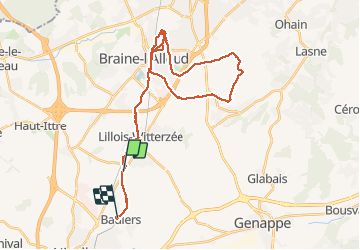
Tour Wandern von 36 km verfügbar auf Wallonien, Wallonisch-Brabant, Braine-l’Alleud. Diese Tour wird von dujcricri vorgeschlagen.
Beschreibung
Circuit de Christiane
Lillois Braine (Félix) boucle Plancenoit ND de Fichermont Lion Braine (Félix) et retour Baulers total 36 km
Ort
Land:
Belgium
Region :
Wallonien
Abteilung/Provinz :
Wallonisch-Brabant
Kommune :
Braine-l’Alleud
Standort:
Lillois-Witterzée
Gehen Sie:(Dec)
Gehen Sie:(UTM)
595890 ; 5609902 (31U) N.
Kommentare
Touren in der Umgebung
![Tour Wandern Nivelles - RB-Bw-16_Monstreux_via-racc-1 - Photo](https://media.geolcdn.com/t/375/260/ext.jpg?maxdim=2&url=https%3A%2F%2Fservices.sitytrail.com%2FGeolivesWS%2FDownloadMedia.ashx%3FTrailID%3D354126%26Media%3Ddaedf7ee-f25e-4941-815b-dbbb8c629e47.jpg)
![Wandern Wandern](https://static1.geolcdn.com/sitytour/trail-icons/101.png)
RB-Bw-16_Monstreux_via-racc-1
Wandern
Schwierig
(11)
Nivelles,
Wallonien,
Wallonisch-Brabant,
Belgium
![](/images/other/stat-length.png)
12,8 km | 15 km-effort
3h 24min
![](https://static1.geolcdn.com/siteimages/upload/files/16400158638029165_repeat_loop_refresh_sync_direction_icon.png)
Ja
![Tour Wandern Nivelles - RB-BW-16 - Raccourci 1 - Par monts et canaux, de part et d’autre de la Thines - Photo](https://media.geolcdn.com/t/375/260/ext.jpg?maxdim=2&url=https%3A%2F%2Fservices.sitytrail.com%2FGeolivesWS%2FDownloadMedia.ashx%3FTrailID%3D221718%26Media%3Ddaedf7ee-f25e-4941-815b-dbbb8c629e47.jpg)
![Wandern Wandern](https://static1.geolcdn.com/sitytour/trail-icons/101.png)
RB-BW-16 - Raccourci 1 - Par monts et canaux, de part et d’autre de la Thines
Wandern
Schwierig
(9)
Nivelles,
Wallonien,
Wallonisch-Brabant,
Belgium
![](/images/other/stat-length.png)
16 km | 18,9 km-effort
4h 17min
![](https://static1.geolcdn.com/siteimages/upload/files/16400158638029165_repeat_loop_refresh_sync_direction_icon.png)
Ja
![Tour Wandern Nivelles - RB-Bw-16_Monstreux - Photo](https://media.geolcdn.com/t/375/260/ext.jpg?maxdim=2&url=https%3A%2F%2Fservices.sitytrail.com%2FGeolivesWS%2FDownloadMedia.ashx%3FTrailID%3D179591%26Media%3D606a627b-9c11-4c95-a0ed-8415395e822e.jpg)
![Wandern Wandern](https://static1.geolcdn.com/sitytour/trail-icons/101.png)
RB-Bw-16_Monstreux
Wandern
Sehr schwierig
(10)
Nivelles,
Wallonien,
Wallonisch-Brabant,
Belgium
![](/images/other/stat-length.png)
20 km | 24 km-effort
5h 24min
![](https://static1.geolcdn.com/siteimages/upload/files/16400158638029165_repeat_loop_refresh_sync_direction_icon.png)
Ja
![Tour Wandern Braine-l’Alleud - #221003 - Braine-l'Alleud, Timpe et Tard et Bois du Foriest, Parc et Lac du Paradis*** - Photo](https://media.geolcdn.com/t/375/260/ext.jpg?maxdim=2&url=https%3A%2F%2Fmedia.geolcdn.com%2Ff%2F7ca9587d-0fe0-4627-96a6-2d18fe7f584a.jpg)
![Wandern Wandern](https://static1.geolcdn.com/sitytour/trail-icons/101.png)
#221003 - Braine-l'Alleud, Timpe et Tard et Bois du Foriest, Parc et Lac du P...
Wandern
Medium
(1)
Braine-l’Alleud,
Wallonien,
Wallonisch-Brabant,
Belgium
![](/images/other/stat-length.png)
8,1 km | 9,8 km-effort
2h 13min
![](https://static1.geolcdn.com/siteimages/upload/files/16400158638029165_repeat_loop_refresh_sync_direction_icon.png)
Ja
![Tour Wandern Nivelles - #230703 - Baulers, champ de Florifontaine - Photo](https://media.geolcdn.com/t/375/260/ext.jpg?maxdim=2&url=https%3A%2F%2Fstatic1.geolcdn.com%2Fsiteimages%2Fupload%2Ffiles%2F1553511878bg_sport_marche.png)
![Wandern Wandern](https://static1.geolcdn.com/sitytour/trail-icons/101.png)
#230703 - Baulers, champ de Florifontaine
Wandern
Medium
(1)
Nivelles,
Wallonien,
Wallonisch-Brabant,
Belgium
![](/images/other/stat-length.png)
6,7 km | 7,6 km-effort
1h 43min
![](https://static1.geolcdn.com/siteimages/upload/files/16400158638029165_repeat_loop_refresh_sync_direction_icon.png)
Ja
![Tour Wandern Nivelles - Balade à Monstreux - Nivelles - Photo](https://media.geolcdn.com/t/375/260/ext.jpg?maxdim=2&url=https%3A%2F%2Fmedia.geolcdn.com%2Ff%2Fdb0b68aa-f936-44ad-bcc2-4769dfb1c9e0.jpeg)
![Wandern Wandern](https://static1.geolcdn.com/sitytour/trail-icons/101.png)
Balade à Monstreux - Nivelles
Wandern
Medium
Nivelles,
Wallonien,
Wallonisch-Brabant,
Belgium
![](/images/other/stat-length.png)
9,1 km | 10,7 km-effort
2h 26min
![](https://static1.geolcdn.com/siteimages/upload/files/16400158638029165_repeat_loop_refresh_sync_direction_icon.png)
Ja
![Tour Mountainbike Nivelles - Ittre_20211120_090138 (1) - Photo](https://media.geolcdn.com/t/375/260/ext.jpg?maxdim=2&url=https%3A%2F%2Fmedia.geolcdn.com%2Ff%2F74b72ae2-2888-436a-9d48-d52a70df61b7.JPG)
![Mountainbike Mountainbike](https://static1.geolcdn.com/sitytour/trail-icons/202.png)
Ittre_20211120_090138 (1)
Mountainbike
Sehr leicht
Nivelles,
Wallonien,
Wallonisch-Brabant,
Belgium
![](/images/other/stat-length.png)
44 km | 52 km-effort
Unbekannt
![](https://static1.geolcdn.com/siteimages/upload/files/16400158638029165_repeat_loop_refresh_sync_direction_icon.png)
Ja
![Tour Mountainbike Braine-l’Alleud - belle balade VTC sans boue, même après beaucoup de pluie - Photo](https://media.geolcdn.com/t/375/260/ext.jpg?maxdim=2&url=https%3A%2F%2Fstatic1.geolcdn.com%2Fsiteimages%2Fupload%2Ffiles%2F1524743154velo.jpg)
![Mountainbike Mountainbike](https://static1.geolcdn.com/sitytour/trail-icons/202.png)
belle balade VTC sans boue, même après beaucoup de pluie
Mountainbike
Sehr leicht
(1)
Braine-l’Alleud,
Wallonien,
Wallonisch-Brabant,
Belgium
![](/images/other/stat-length.png)
32 km | 38 km-effort
2h 55min
![](https://static1.geolcdn.com/siteimages/upload/files/16400158638029165_repeat_loop_refresh_sync_direction_icon.png)
Ja
![Tour Hybrid-Bike Braine-l’Alleud - VTC macasam 46 km Braine-l'alleud, Arquennes - Photo](https://media.geolcdn.com/t/375/260/ext.jpg?maxdim=2&url=https%3A%2F%2Fstatic1.geolcdn.com%2Fsiteimages%2Fupload%2Ffiles%2F1524743154velo.jpg)
![Hybrid-Bike Hybrid-Bike](https://static1.geolcdn.com/sitytour/trail-icons/203.png)
VTC macasam 46 km Braine-l'alleud, Arquennes
Hybrid-Bike
Sehr leicht
(1)
Braine-l’Alleud,
Wallonien,
Wallonisch-Brabant,
Belgium
![](/images/other/stat-length.png)
45 km | 50 km-effort
2h 54min
![](https://static1.geolcdn.com/siteimages/upload/files/16400158638029165_repeat_loop_refresh_sync_direction_icon.png)
Ja