![](/images/other/stat-length.png)
![Tour Mountainbike La Motte-Servolex - Mont Grelle - Photo](https://media.geolcdn.com/t/1900/400/ext.pjpeg?maxdim=2&url=https%3A%2F%2Fservices.sitytrail.com%2FGeolivesWS%2FDownloadMedia.ashx%3FTrailID%3D128926%26Media%3Db47025db-f651-440f-aee9-50e0f8f38084.jpg)
Mont Grelle
baudrine
Benutzer
![Länge](/images/other/stat-length.png)
Länge
41 km
![Maximale Höhe](https://static1.geolcdn.com/siteimages/upload/files/1508320355ic_sort_altitude_max_24dp.png)
Maximale Höhe
1407 m
![Positive Höhendifferenz](https://static1.geolcdn.com/siteimages/upload/files/1508320355ic_sort_den_pos_24dp.png)
Positive Höhendifferenz
1694 m
![Km-Effort](/images/other/stat-length.png)
Km-Effort
63 km
![Min. Höhe](https://static1.geolcdn.com/siteimages/upload/files/1508320355ic_sort_altitude_min_24dp.png)
Min. Höhe
297 m
![Negative Höhendifferenz](https://static1.geolcdn.com/siteimages/upload/files/1508320355ic_sort_den_neg_24dp.png)
Negative Höhendifferenz
1694 m
![Boucle](https://static1.geolcdn.com/siteimages/upload/files/16400158638029165_repeat_loop_refresh_sync_direction_icon.png)
Boucle
Ja
Erstellungsdatum :
2014-12-10 00:00:00.0
Letzte Änderung :
2014-12-10 00:00:00.0
![Mountainbike](https://static1.geolcdn.com/sitytour/trail-icons/202.png)
5h36
Schwierigkeit : Schwierig
![Scannen Sie diesen QR-Code, um die Tour in der SityTrail-Anwendung zu öffnen](https://capi.geolives.com/qq0zvz2zws4bq2lad0pu/sitytour/trails/128926/qr.png?size=200)
Kostenlosegpshiking-Anwendung
Über SityTrail
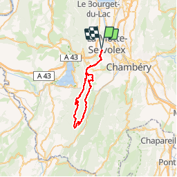
Tour Mountainbike von 41 km verfügbar auf Auvergne-Rhone-Alpen, Savoyen, La Motte-Servolex. Diese Tour wird von baudrine vorgeschlagen.
Beschreibung
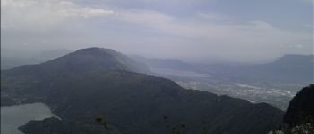
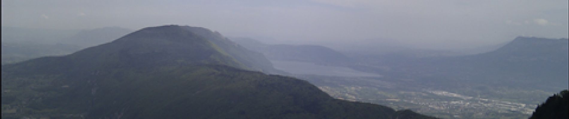
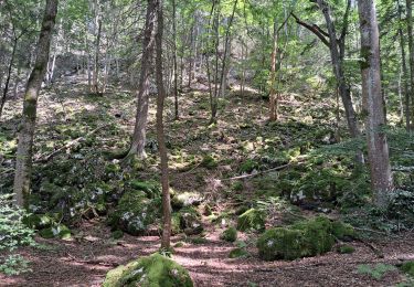
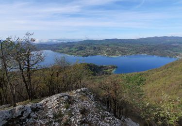
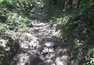
Randonnée plutôt difficile (tout dépend des conditions physique de chacun). Il y a pas mal de portage (montée comme descente). Arrivée en haut du Mont Grelle => quelle vue!!!
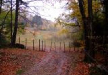
A la descente, attention aux passages difficiles (en bord de falaise).
Ort
Land:
France
Region :
Auvergne-Rhone-Alpen
Abteilung/Provinz :
Savoyen
Kommune :
La Motte-Servolex
Standort:
Unknown
Gehen Sie:(Dec)
Gehen Sie:(UTM)
723532 ; 5052643 (31T) N.
Kommentare
Touren in der Umgebung
![Tour Mountainbike Le Bourget-du-Lac - Chartreuse - Col du Crucifix - Photo](https://media.geolcdn.com/t/375/260/ext.jpg?maxdim=2&url=https%3A%2F%2Fservices.sitytrail.com%2FGeolivesWS%2FDownloadMedia.ashx%3FTrailID%3D102126%26Media%3D2516_1.jpg)
![Mountainbike Mountainbike](https://static1.geolcdn.com/sitytour/trail-icons/202.png)
Chartreuse - Col du Crucifix
Mountainbike
Schwierig
(2)
Le Bourget-du-Lac,
Auvergne-Rhone-Alpen,
Savoyen,
France
![](/images/other/stat-length.png)
27 km | 40 km-effort
4h 0min
![](https://static1.geolcdn.com/siteimages/upload/files/16400158638029165_repeat_loop_refresh_sync_direction_icon.png)
Ja
![Tour Mountainbike Cognin - Autour du Corbeley - Photo](https://media.geolcdn.com/t/375/260/ext.jpg?maxdim=2&url=https%3A%2F%2Fstatic1.geolcdn.com%2Fsiteimages%2Fupload%2Ffiles%2F1524743154velo.jpg)
![Mountainbike Mountainbike](https://static1.geolcdn.com/sitytour/trail-icons/202.png)
Autour du Corbeley
Mountainbike
Medium
(1)
Cognin,
Auvergne-Rhone-Alpen,
Savoyen,
France
![](/images/other/stat-length.png)
25 km | 38 km-effort
2h 23min
![](https://static1.geolcdn.com/siteimages/upload/files/16400158638029165_repeat_loop_refresh_sync_direction_icon.png)
Ja
![Tour Pfad La Motte-Servolex - Château Richard et croix du Signal - Photo](https://media.geolcdn.com/t/375/260/ext.jpg?maxdim=2&url=https%3A%2F%2Fmedia.geolcdn.com%2Ff%2F3752241f-e62c-4bc8-86ee-aa981979bc96.jpg)
![Pfad Pfad](https://static1.geolcdn.com/sitytour/trail-icons/104.png)
Château Richard et croix du Signal
Pfad
Medium
La Motte-Servolex,
Auvergne-Rhone-Alpen,
Savoyen,
France
![](/images/other/stat-length.png)
11,1 km | 20 km-effort
2h 1min
![](https://static1.geolcdn.com/siteimages/upload/files/16400158638029165_repeat_loop_refresh_sync_direction_icon.png)
Ja
![Tour Wandern Aiguebelette-le-Lac - Mont Grêle - Photo](https://media.geolcdn.com/t/375/260/ext.jpg?maxdim=2&url=https%3A%2F%2Fmedia.geolcdn.com%2Ff%2F4dc3a178-8cfd-47eb-bb85-9b4370a887ab.jpg)
![Wandern Wandern](https://static1.geolcdn.com/sitytour/trail-icons/101.png)
Mont Grêle
Wandern
Medium
Aiguebelette-le-Lac,
Auvergne-Rhone-Alpen,
Savoyen,
France
![](/images/other/stat-length.png)
16,3 km | 30 km-effort
5h 0min
![](https://static1.geolcdn.com/siteimages/upload/files/16400158638029165_repeat_loop_refresh_sync_direction_icon.png)
Ja
![Tour Wandern Aiguebelette-le-Lac - Belvédère du Rocher du Corbeau - Photo](https://media.geolcdn.com/t/375/260/ext.jpg?maxdim=2&url=https%3A%2F%2Fmedia.geolcdn.com%2Ff%2Fce4a0898-93e9-4db9-96e7-643f23060884.jpg)
![Wandern Wandern](https://static1.geolcdn.com/sitytour/trail-icons/101.png)
Belvédère du Rocher du Corbeau
Wandern
Schwierig
(1)
Aiguebelette-le-Lac,
Auvergne-Rhone-Alpen,
Savoyen,
France
![](/images/other/stat-length.png)
5 km | 9,3 km-effort
2h 7min
![](https://static1.geolcdn.com/siteimages/upload/files/16400158638029165_repeat_loop_refresh_sync_direction_icon.png)
Ja
![Tour Wandern Saint-Sulpice - Col du Crucifix par St Sulpice - Photo](https://media.geolcdn.com/t/375/260/ext.jpg?maxdim=2&url=https%3A%2F%2Fmedia.geolcdn.com%2Ff%2F5e4f15e7-0d3c-4d79-ac78-7dd8bd1d22d1.jpg)
![Wandern Wandern](https://static1.geolcdn.com/sitytour/trail-icons/101.png)
Col du Crucifix par St Sulpice
Wandern
Medium
Saint-Sulpice,
Auvergne-Rhone-Alpen,
Savoyen,
France
![](/images/other/stat-length.png)
5,5 km | 10,5 km-effort
2h 40min
![](https://static1.geolcdn.com/siteimages/upload/files/16400158638029165_repeat_loop_refresh_sync_direction_icon.png)
Ja
![Tour Wandern Aiguebelette-le-Lac - l'épine d'Aiguelette - Photo](https://media.geolcdn.com/t/375/260/ext.jpg?maxdim=2&url=https%3A%2F%2Fmedia.geolcdn.com%2Ff%2Fc39bd45d-0ff0-494c-b0f6-caf086df8953.jpg)
![Wandern Wandern](https://static1.geolcdn.com/sitytour/trail-icons/101.png)
l'épine d'Aiguelette
Wandern
Schwierig
Aiguebelette-le-Lac,
Auvergne-Rhone-Alpen,
Savoyen,
France
![](/images/other/stat-length.png)
7,5 km | 12,9 km-effort
3h 38min
![](https://static1.geolcdn.com/siteimages/upload/files/16400158638029165_repeat_loop_refresh_sync_direction_icon.png)
Ja
![Tour Wandern Chambéry - Cascades de Jacob - Photo](https://media.geolcdn.com/t/375/260/ext.jpg?maxdim=2&url=https%3A%2F%2Fmedia.geolcdn.com%2Ff%2Fe897f97f-bc4f-47ad-8cbc-412ddc550437.jpg)
![Wandern Wandern](https://static1.geolcdn.com/sitytour/trail-icons/101.png)
Cascades de Jacob
Wandern
Einfach
Chambéry,
Auvergne-Rhone-Alpen,
Savoyen,
France
![](/images/other/stat-length.png)
10 km | 14 km-effort
2h 0min
![](https://static1.geolcdn.com/siteimages/upload/files/16400158638029165_repeat_loop_refresh_sync_direction_icon.png)
Ja
![Tour Wandern Aiguebelette-le-Lac - le colle du crussifi - Photo](https://media.geolcdn.com/t/375/260/ext.jpg?maxdim=2&url=https%3A%2F%2Fmedia.geolcdn.com%2Ff%2F53e655b3-14da-4ab0-b35d-5ab7c9ac3e6e.jpg)
![Wandern Wandern](https://static1.geolcdn.com/sitytour/trail-icons/101.png)
le colle du crussifi
Wandern
Einfach
Aiguebelette-le-Lac,
Auvergne-Rhone-Alpen,
Savoyen,
France
![](/images/other/stat-length.png)
16,6 km | 32 km-effort
3h 40min
![](https://static1.geolcdn.com/siteimages/upload/files/16400158638029165_repeat_loop_refresh_sync_direction_icon.png)
Nein